


|
||

|

|
|

|
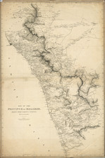
A Field Copy Carried By Edward Holmes in 1817
Stunning large format map of India, first published by Aaron Arrowmsith in 1804.
The map was apparently used by Lieutenant Edward Holmes, who died on October 17, 1817, during the Third Anglo-Maratha War, near the BEIC fort at Darwar. It would appear that at the time of his death, Holmes was deployed under the command of Lieutenant-Colonel David Newall. In July 1817, Newall was chosen to command a detachment from the division of Colonel Theophilus Pritzler, tasked with recovering the fortresses of Koorhgul and Darwar from the Peishwa. Following the recovery of the forts, Newall was named Commandant of the garrison and fortress of Darwar. The annotations below indicate the Holmes died on October 17, 1817 and was buried near the fort at Darwar, the first ever British soldier to be so interred.
Arrowsmith's map outlines the British territories and zones of interest in India as they stood at the beginning of the 19th Century India, under the management of the British East India Company (BEIC), was crucial to the British Empire both as a resource and a gateway to further Asian expansion.
At the time of this map's creation, the British grip on the Subcontinent was not yet complete, as painfully noted by the hand written epitaph to its owner, Edward Holmes. The map shows varying detail across different regions or presidencies controlled by the BEIC, reflecting their importance within trade networks. Coastal areas like Bengal and Andhra Pradesh to the north, as well as the Coromandel and Malabar coasts to the south, are depicted with significant clarity. Sri Lanka, referred to as Ceylon at that time, is also intricately detailed, indicating where British efforts were focused. The map extends detailed attention to inland areas from the Bay of Bengal towards Uttar Pradesh, Delhi, and the Indus Valley, signaling the expansion of colonial objectives.
Arrowsmith incorporated extensive place names and utilized British Army records from route surveys for an accurate portrayal of India’s transportation network. The map’s detail extends to topographical features, notes on natural resources, and advice for seasonal navigation, particularly the maritime approach to Calcutta.
The map also reflects the symbiotic relationship between military operations and cartography, with the British Army charting territories as they traversed them. This is exemplified by the map’s dedication to Sir Mark Wood, an officer and engineer who served notably in India, eventually becoming the surveyor-general and chief engineer of Bengal. His work was instrumental in providing the foundational knowledge that underpinned Arrowsmith’s cartographic representation.
Annotations
Memorandum
Lieut. Edward Holmes 2nd Bn. 4th Regt. Madras [Chennai] N.I. died at Darwar on 28th Octr 1817 lies interned a few yards from the left of the road leading to Hoobly into the Fort and was the first European buried there. Dawar given up in August 1817 to 20d 4th Rt. Major D. Newall. [Lieutenant-Colonel David Newall, the Commandant of Darwar]
H. Holmes his Map
Edward re-joined 2nd Lt on 13th August from Madras where he had been with Treasury from Cuddapah [Kadapah] / I met him at Hoogly on 12 August in the camp of Genl [Sir Theophilius] Pritzler = We marched to Dharwar on 13th. I joined 2nd 4th at Ghooty [Gooty, Andhra Pradesh] on 19 or 20th June - by G-Orders having returned my steps / homeward / from Cuddapah, on the Evening of 15 or 16th June, when I reached Gooty I found orders to do duty with 2nd Bn 4th Regt till further orders - Command with that Corps till the 28th Decr left them on that Evening on the Boombudra & joined 2nd ? 16th Regt. on Evening ? Jan 7 - 1818 at Chittledroog [Chitradurga] remained then late 1st Feby I left for Madras on Sick Certificate arrived at Madras 19 Feby left at 2pm 10th March for England.
Mahratta War
The Mahratta War at the beginning of the 19th century involved the British East India Company in conflict with various Mahratta states such as Sattara, Berar, Scindia, and Holkar. The Marquis Wellesley, then Governor-General, oversaw these military efforts. Key events of this period included the significant battles of Assaye and Argaum, which marked the early military career of the future Duke of Wellington. Other notable victories, such as those at Delhi, Lasswarree, Deeg, and Futtehghur, were achieved under Lord Lake. These battles also led to the British offering protection to the Mogul emperor, who had been under Mahratta control.
The British acquired several territories during this period, including lands from Oude and the Delhi territory, with significant expansions in 1801, 1802, 1803, and 1805 into areas such as the lower Doab and Gujerat.
Subsequently, the British faced the Pindarees, a group of marauding fighters allied with some Mahratta factions, and the Goorkhas from Nepaul, who had encroached upon British territories. In 1817, as part of the Third Anglo-Maratha War, British forces began advancing against the Pindarees around mid-October. Key battles ensued as the Peshwa and other Maratha leaders like the raja of Nagpore and Holkar instigated uprisings against the British East India Company. The Pindarees were eventually defeated and their leaders captured or killed, marking the end of the Pindaree menace by 1819. The conflict significantly contributed to the consolidation of British power in India. The capture of Bhurtpoor in January 1826 was another significant event, as it had previously resisted British attacks.
The period also saw an expansion of British control with the annexation of regions like Kumaon from Nepaul in 1815, and the acquisition of territories such as the Saugur and Darwar districts, Ahmedabad, Candeish, Ajmere, Poonah, and the south Mahratta country following the resolution of these conflicts. These additions greatly expanded the British presence in India, particularly with several incorporations into the Bombay presidency in 1820 and 1822.
General Sir Theophilus Pritzler
Pritzler was an officer in the British Army who began his military career in 1793. By 1794, he had become a lieutenant in the 85th Foot and later served in the 5th Dragoon Guards during campaigns in Holland and Germany. His military engagements also took him to San Domingo from 1796 to 1798. In September 1796, he transferred to the 21st Light Dragoons and in 1804 was appointed major in the Royal Fusiliers. His administrative military roles included serving as major of brigade at Portsmouth and as assistant adjutant-general at the Horse Guards. Pritzler was promoted to lieutenant-colonel in 1807 and appointed to the same rank in the 22nd Light Dragoons in 1813, followed by a colonel brevet in 1814.
Pritzler's tenure in India was marked by his leadership during the third Mahratta War starting in 1817. As brigadier-general, he was instrumental in pursuing the Peishwa following the latter's flight from Poona. His military actions included significant confrontations near Satura and Meritch, and successful sieges of fortresses such as Singhur and Wasota. His efforts culminated in the capture of Sholapur and the dispersal of the Mahratta garrison.
He was knighted as a K.C.B. (Knight Commander of the Order of the Bath) in 1822 and passed away in 1839. His career up to 1830 was characterized by a series of promotions and notable military actions, reflecting a period of service that was significant for its time.
Rarity
Very rare: only 3 copies found on WorldCat: British Library, Harvard and Bibliothèque Nationale de France.
The Arrowsmiths were a cartographic dynasty which operated from the late-eighteenth century to the mid-nineteenth. The family business was founded by Aaron Arrowsmith (1750-1823), who was renowned for carefully prepared and meticulously updated maps, globes, and charts. He created many maps that covered multiple sheets and which were massive in total size. His spare yet exacting style was recognized around the world and mapmakers from other countries, especially the young country of the United States, sought his maps and charts as exemplars for their own work.
Aaron Arrowsmith was born in County Durham in 1750. He came to London for work around 1770, where he found employment as a surveyor for the city’s mapmakers. By 1790, he had set up his own shop which specialized in general charts. Arrowsmith had five premises in his career, most of which were located on or near Soho Square, a neighborhood the led him to rub shoulders with the likes of Joseph Banks, the naturalist, and Matthew Flinders, the hydrographer.
Through his business ties and employment at the Hydrographic Office, Arrowsmith made other important relationships with Alexander Dalrymple, the Hudson’s Bay Company, and others entities. In 1810 he became Hydrographer to the Prince of Wales and, in 1820, Hydrographer to the King.
Aaron Arrowsmith died in 1823, whereby the business and title of Hydrographer to the King passed to his sons, Aaron and Samuel, and, later, his nephew, John. Aaron Jr. (1802-1854) was a founder member of the Royal Geographical Society (RGS) and left the family business in 1832; instead, he enrolled at Oxford to study to become a minister. Samuel (1805-1839) joined Aaron as a partner in the business and they traded together until Aaron left for the ministry. Samuel died at age 34 in 1839; his brother presided over his funeral. The remaining stock and copper plates were bought at auction by John Arrowsmith, their cousin.
John (1790-1873) operated his own independent business after his uncle, Aaron Arrowsmith Sr., died. After 1839, John moved into the Soho premises of his uncle and cousins. John enjoyed considerable recognition in the geography and exploration community. Like Aaron Jr., John was a founder member of the RGS and would serve as its unofficial cartographer for 43 years. Several geographical features in Australia and Canada are named after him. He carried the title Hydrographer to Queen Victoria. He died in 1873 and the majority of his stock was eventually bought by Edward Stanford, who co-founded Stanford’s map shop, which is still open in Covent Garden, London today.

![[ India ] Presqu Isle De L'Inde Decale Golfe De Bengala](https://storage.googleapis.com/raremaps/img/small/97365.jpg)