|
||

|

|
|

|
Martino Fine Press Edition of the The Definitive Work on Mapping Mapping The American West, 1540-1861: Carl Wheat's Magnum Opus
In the annals of cartographic history, few works stand as tall and profound as Carl Wheat's monumental six-volume work, "Mapping the Transmississippi West, 1540-1861". First published in San Francisco by the Institute of Historical Cartography between 1957 and 1963, this magnum opus is heralded as the most comprehensive cartobibliography of the regions west of the Mississippi River. Its scope, detail, and vast historical expanse establish it as the gold standard of its kind.
The present example is the Martino Fine Press edition, issued in 1995.
Wheat's work, colloquially referred to as "Wheat" in scholarly circles, spans an epochal period: from the Spanish Entrada in the mid-16th century to the Civil War's culmination in the 19th century. In doing so, it meticulously details the mapping of a territory that witnessed dramatic transformations in its landscape, political jurisdictions, and social fabric. The Transmississippi region holds a special place in American history, representing an area of exploration, colonization, and expansion. By chronicling its maps, Wheat's work effectively chronicles the history of the West itself.
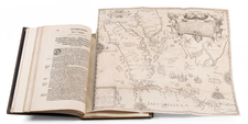
Encompassing over 1,600 pages, the work is both extensive and detailed. It showcases more than 300 high-quality reproductions of rare maps and plans, some spanning two pages, thereby presenting the reader with a visual journey across time and territory. Accompanying these maps is a Carto-bibliocartography that describes 1,302 maps in detail. This combination of visual and textual content renders "Wheat" an invaluable resource for historians, geographers, and anyone interested in the evolution of the American West.
Designed by the renowned Edwin and Robert Grabhorn, with the first volume printed by the Grabhorn Press and the subsequent volumes by Taylor, Taylor, and James, the work also reflects the craftsmanship of a bygone era of fine press printings.
To conclude, "Mapping the Transmississippi West, 1540-1861" is more than just a collection of maps; it's a monumental achievement in cartographic scholarship. Carl Wheat's dedication to presenting the historical geography of the Transmississippi region in such a detailed and visually compelling manner ensures that his work will remain an indispensable reference for generations to come. As Howell rightly puts it, this work is a testament to a "quarter-century of research" and stands as a beacon of California's rich scholarly tradition.
- Vol. I: The Spanish Entrada to the Louisiana Purchase, 1540-1804
- Vol. II: From Lewis and Clark to Fremont, 1804-1845
- Vol. III: The Mexican War to the Boundary Survey, 1846-1854
- Vol. IV: Pacific Railroad Surveys to the onset of the Civil War, 1855-1860
- Vol. V: (Parts 1 and 2) Civil War to the Geological Survey.
Collation
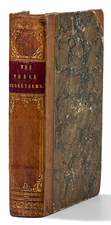
5 volumes in 6. Illustrated throughout with facsimile maps, many of which are folding; color frontispieces. 14x10", green cloth-backed beige cloth, spines lettered in gilt. One of 350 sets, published by Mauritzio Martino.

![(Map Seller's Canvassing Book) Subscribers to the Map of Greene County by Simon J. Martenet, Surveyor & Civ. Eng., Baltimore, Md, 1858 [Manuscript subscription book for Martenet map of Greene Co., Pennsylvania]](https://storage.googleapis.com/raremaps/img/small/77428.jpg)