|
||

|

|
|

|
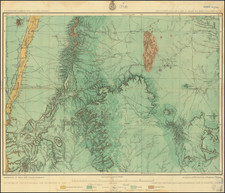
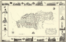
An interesting example is the Parke-Kern map of New Mexico Territory - the most important map of the newly formed Territory of New Mexico.
Lt. John G. Parke's map of the Territory of New Mexico is a landmark work in the history of the region. Published in 1852, the map covers the region from Pike's Peak in the north to Cooke's Wagon Road in Sonora. Prepared in 1851 by Richard Kern, the map replaced Stephen W. Kearny and Lt. J. W. Abert's as the primary source of geographical information on New Mexico.
Parke initially sent his manuscript map to the War Department, where it was printed and distributed to officers headed to the region and others who requested a copy, but it was never bound into a report or sold commercially. The intention was to use the map as a base map for observations by field officers who were then sent to the region. As noted by Wheat (pages 131-132):
Parke's published map is a remarkable production, both because it is a composite of the maps hitherto described, and because of the wealth of additional information contained on it. It would be of little assistance to attempt to describe this latter aspect of this map; it must be gained from a view of the map itself.... North of the route proposed by Simpson at such length the canyons of the Colorado are not shown, but the Moqui (Hopi) country, the Cerro Abajo and the Cerro la Sal, and the Green and the Grand rivers appear.... In the far northwest, in Utah Territory below the Wasatch range, and stretching east from Vegas (Las Vegas, Nevada), is "The Spanish Trail leading from the Pueblo de los Angeles California to Abiquiu New Mexico".... The names along the upper Grand River, and in the valley at the head of the Rio Grande del Norte, are remarkable in that they here appear so early, and though this whole country on the north and west is labeled "Unexplored," this map must have been an eye-opener to Beale and Frémont, who passed through the Green and Grand area on their separate ways to California in 1853.
Manuscript Amendments
An early French user has modified this example with specific reference to General Kearny's 1847 map of New Mexico Territory. Some of the notes and topographical features from that map have been written in French and redrawn on the present map. For instance, near the Sierra de Los Jumanes are notes about there being a very fertile plateau and nearby another high plateau without water is described in French. These notes are translated directly from Kearny's map.
An early and incorrect rendition of the Gadsden Purchase border line has been drawn west from El Paso. In this rendition, it proceeds southwest (rather than west and due south), and, as a result, includes Lac de Guzman (Laguna de Guzmán) in the territory of the United States.
Rarity
Because the map was never published in an official report and was only issued separately, it is now rare on the market.
The only copy to appear at auction in the last 15 years made $22,800 at PBA Galleries in 2015.
![La Parte Occidentale Dell'Antico, E Nuovo Messico Con Florida E La Bassa Luigiana…. 1798 [California & The Southwest!]](https://storage.googleapis.com/raremaps/img/small/95816.jpg)