|
||

|

|
|

|
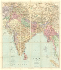
Rare Wall Map of India From the Year of the Mutiny.
This large 1857 wall map of India, published by Edward Stanford in London, presents a detailed depiction of the Indian subcontinent during a pivotal period of British colonial expansion. It is based on surveys executed by the Honorable East India Company, incorporating special maps from the Surveyor General and other authorities, and highlights the latest territorial acquisitions of the British Empire along with the independent and protected states. The map also marks railways, canals, and other significant features, offering a comprehensive overview of the region's geography and British imperial interests in the mid-19th century.
The historical context of this map is deeply intertwined with the era of British colonialism in India. By 1857, the British East India Company had established substantial control over large parts of India, leading to profound changes in the region's political, social, and economic landscapes. This map, created in the same year as the Indian Rebellion of 1857, a pivotal uprising against British rule, serves as a crucial document reflecting the geopolitical realities of the time. It captures the extent of British influence and territorial control just before the British Crown took direct control over India, marking the end of the Company's rule.
The map's detail and accuracy are notable, with features such as railways and canals emphasized, reflecting the infrastructural developments introduced by the British. It also includes an inset, "The Malay Peninsula &c. Showing The British Possessions Beyond the Ganges," broadening the geographical context.
The color coding used in the map—British possessions in red (more pink, and perhaps yellow?), independent states in green, French settlements in blue, and Portuguese in brown—visually delineates the complex colonial dynamics of the region. Moreover, the inclusion of a "Chronological Table of the Various Acquisitions Made to the British Empire in India" compiled from parliamentary returns and other official sources, offers a comprehensive historical account of British expansion in India up to 1856.
Additional notes on the map provide further insights into the colonial administration and its relations with local rulers. The list of "Pensioners of Great Britain," including figures like the King of Delhi and the Nawab of Bengal, reveals the intricate web of alliances and dependencies that characterized British rule in India. These notes, along with other detailed references such as military stations, post-offices, and distance diagrams, reflect the complexities of British colonial governance and its impact on the Indian subcontinent.
Edward Stanford (1827-1904) was a prominent British mapmaker and publisher. A native of Holborn in the heart of London, Edward was apprenticed to a printer and stationer at the age of 14. After his first master died, he worked with several others, including Trelawny W. Saunders of Charing Cross. Saunders oversaw young Edward’s early career, ensuring that he became a Fellow of the Royal Geographical Society. Associations with the Society eventually brought Sanders much business and gave him a reputation as a publisher of explorers. As testament to this reputation, the Stanford Range in British Columbia was named for him by John Palliser.
Stanford briefly partnered with Saunders in 1852 before striking out on his own in 1853. He was an agent for the Ordnance Survey, the Admiralty, the Geological Survey, the Trigonometrical Survey of India, and the India Office. He also controlled the maps of the Society for the Diffusion of Useful Knowledge, another lucrative source of income. In 1857, Stanford founded his namesake Geographical Establishment, with Saunders and A. K. Johnston as engravers. Thereafter, Stanford was known for his “library maps”, particularly those of Africa and Asia.
Addresses and Years of Operation:
- 6 Charing Cross, London (1848): Edward Stanford's initial place of employment at Trelawney Saunders' shop.
- 7 and 8 Charing Cross, London (1853): Stanford expanded his shop to these addresses.
- 55 Charing Cross, London (1873): The shop moved to this larger location.
- 12-14 Long Acre, London (1873): Site of the new print works and current flagship store.
- 7 Mercer Walk, London (2019): Stanfords moved to this address, continuing its legacy.
Stanford's work with Chief Cartographer John Bolton, including the 1858 Library Map of Europe, positioned the company as a leader in quality cartography during a time of exploration and colonialism. Their 1862 Library Map of London earned acclaim from the Royal Geographical Society. With the business thriving, Stanford purchased Staunton & Son in 1877 and, upon retiring in 1885, handed over the reins to his son, Edward Stanford II.
As sole agents for Ordnance Survey Maps, the company's influence and reputation grew, culminating in the Stanford’s London Atlas Of Universal Geography, which was presented to Queen Victoria in 1887. The transition into the 20th century saw further integration of retail, print, and cartographic operations at Long Acre.
During World War I, Stanford's became an essential publisher for the War Office. Edward Fraser Stanford took over in 1917, steering the company through the interwar period and innovations, such as the world’s smallest maps in 1922 and the Daily Mail Motor Road Map in 1926.
Withstanding a bombing in WWII, the company continued under the stewardship of John Keith Stanford and was sold to George Philip & Son in 1947. As it adapted to the digital age, Stanfords received the Ordnance Survey Premier Partner status in 2007 and ventured into online mapping and data services.
Stanfords, now an icon for travellers and explorers, has maintained its cultural relevance and retail success well into the 21st century, underpinned by a legacy of entrepreneurial spirit and commitment to cartographic excellence.