


|
||

|

|
|

|
Stock# 99723
Description
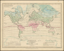
Phytogeographic map of the world, according to August Grisebach's 1872 work Die Vegetation der Erde nach Ihrer Klimatischen Anordnung (The Earth's vegetation after its climatic arrangement), showing the Arctic, Eurasian forests, Mediterranean, the Steppes, Chinese-Japanese, Indian Monsoon, Sahara, Sudan, Kalahari, Cape, Australian, North American forest, prairies, California coastlands, Mexican, West Indian, cis-equatorial South America, Hylaea (equatorial Brazil), Brazilian, Tropical Andes, Pampas, Chilean transition area, Antarctic forest, and Oceanic island regions Isothermic lines run across the map. The growing limits of palms, grapevines, grains, and trees are shown.
Condition Description
Minor centerfold toning. At bottom margin: crease to the left and short closed tear to the right of centerfold.
![[ Ancient World ] Aevi Veteris, Typus Geographicus](https://storage.googleapis.com/raremaps/img/small/85526.jpg)
![Western Hemisphere. Eastern Hemisphere. [showin the Republic of Texas]](https://storage.googleapis.com/raremaps/img/small/82886.jpg)