|
||

|

|
|

|
Stock# 99719
Description
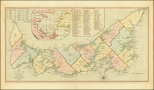
Scarce French and Indian War era map of the area around the entrance to the St. Lawrence River, published in Livorno.
Published shortly after the Treaty of Peace of 1763, the map shows the region bounded by Quebec in the North and Nova Scotia and New Brunswick in the South, with St. Lawerence shown to the Saguenay River.

![[Lake Champlain and environs] Carte de la Riviere de Richelieu et du Lac Champlain](https://storage.googleapis.com/raremaps/img/small/91308.jpg)