|
||

|

|
|

|
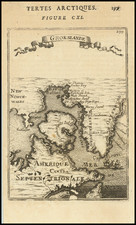
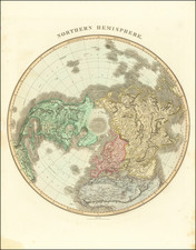
Striking full color example of De Wit's map of the North Polar Regions, based upon the Hondius-Jansson map first issued about 50 years earlier. Shows hope for a Northwest Passage and a very clear NE Passage. The explorations above the artic circle in both regions are shown. A gorgeous full color example with wide margins on strong thick paper. An early color example which has been deacidified and the colors refreshed. The map has been strengthened in several spots on the verso. Overall an attractive copy. Tooley 729.
De Wit (1629 ca.-1706) was a mapmaker and mapseller who was born in Gouda but who worked and died in Amsterdam. He moved to the city in 1648, where he opened a printing operation under the name of The Three Crabs; later, he changed the name of his shop to The White Chart. From the 1660s onward, he published atlases with a variety of maps; he is best known for these atlases and his Dutch town maps. After Frederik’s death in 1706, his wife Maria ran the shop for four years before selling it. Their son, Franciscus, was a stockfish merchant and had no interest in the map shop. At the auction to liquidate the de Wit stock, most of the plates went to Pieter Mortier, whose firm eventually became Covens & Mortier, one of the biggest cartography houses of the eighteenth century.
![(Northern Scandinavia) Carte des Couronnes du Nord Dediée Au très Puissant et très Invincible Prince Charles XII, Roy de Suède, des Gots et des Vandales, Grand Duc de Finlande, &c. &c. &c. [Map of the Northern Crowns Dedicated to the Very Powerful and Invincible Prince Charles XII, King of Sweden, of the Goths and Vandals, Grand Duke of Finland, etc. etc. etc.]](https://storage.googleapis.com/raremaps/img/small/92675.jpg)