|
||

|

|
|

|
Stock# 99503
Description
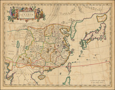
Nice detailed map of China, colored by Provinces, including Corea and "Taiouan or I. Formosa".
This map is from an early edition of Tanner's New Universal Atlas, first issued in 1834. The atlas would become the most popular American atlas between 1834 and 1860. It was published annually, first by Tanner and later by Mitchell, Cowperthwait, and DeSilver.
Tanner's career as a mapmaker began in the early 19th century. He had a hand in publishing many of the most important American maps of the first half of the 19th Century. His business was carried on by his son Thomas and Henry Carey and flourished until the middle of the 19th Century.
![Parte Occidentale della China . . . [with] Parte Orientale della China . . .](https://storage.googleapis.com/raremaps/img/small/75144.jpg)

![Iaponiae Insulae Descriptio Ludoico Teisera auctore [Korea Shown As An Island]](https://storage.googleapis.com/raremaps/img/small/99309.jpg)