|
||

|

|
|

|
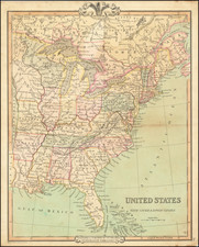
Revolutionary War Map of the Great Lakes, Upper Midwest, etc.
Scarce map of the Northern and Western part of the British Colonies in North America, showing the theater of the American Revolutionary War in 1776.
The map extends north to James Bay, west to the Mississippi River and south to Philadelphia and Pittsburg.
The map is perhaps most noteworthy for its depiction of the extent of the claims shown for Virginia, which extends north to include virtually all of Michigan and Illinois and a large portion of Wisconsin! This map reflects the boundaries of the Virginia Colony that can be seen in maps of from the beginning of the 17th Century, but by the middle of the 18th Century are typically not shown on the western side of Lake Michigan up to Green Bay (Puans Bay on this map).
The map notes the region of "Confederate Indians" south of the Lake Erie and Lake Ontario, along with a number of other Indian Tribes.
![[Eastern Sheet -- Ohio] Post Road Map of the States of Ohio and Indiana with Adjacent Parts of Pennsylvania Michigan Illinois Kentucky and West Virginia Showing Post Offices With The Intermediate Distances and Mail Routes In Operation On the !st of February 1885 . . .](https://storage.googleapis.com/raremaps/img/small/44153.jpg)