|
||

|

|
|

|
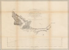
Scarce map of the Coalinga Oil Field, published by the US Geological Survey.
The map is a detailed representation that combines geological and topographical elements of the Coalinga Oil Field, with a specific focus on Oil Zone B at the summit of the Vaqueros Formation. The map illustrates the complex geological structures of the area, emphasizing the stratigraphic layers like the top sandstone in the East Side Field and the lower part of the Jacalitos Formation in the West Side Field. These geological layers are differentiated to indicate various rock formations and their extents, which is crucial for understanding the oil reservoirs beneath.
In terms of topography, the map notes elevations, depressions, and other physical land features, using contour lines to represent changes in elevation. This provides insights into the landscape's influence on the oil field operations. A key feature of the map are the location of oil wells within the Coalinga Oil Field, marked with symbols to indicate both active and inactive wells.
Additionally, the map shows towns and settlements in and around the Coalinga Oil Field, including Coalinga itself and any other smaller communities.
![(Bird's-Eye View of California) San Francisco Invites You [cover title]](https://storage.googleapis.com/raremaps/img/small/92552.jpg)