|
||

|

|
|

|
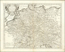
Finely detailed late 18th Century postal map of Germany, published in Nuremberg.
The map details the postal routes across Germany, highlighting where travelers and couriers could find relay stations, the paths used by mail coaches, and the routes exclusively for letter transport. The map also notes the distances between postal stops in Germany, France, and the Low Countries, reflecting the different systems used for measuring and organizing postal services in these areas. Additionally, it marks important locations such as the residences of Electors and princes, imperial cities, and academies, offering insight into the political and educational landscape of the time.
This map is a remarkable window into how the German and European postal services were organized, showing the infrastructure that allowed for the movement of information, goods, and people. The delineation of routes and services reveals the logistics of early modern communication and travel, highlighting the importance of postal networks in connecting different parts of Europe. These networks were crucial for commerce, governance, and the exchange of ideas, playing a significant role in the development of European societies.
Homann Heirs was a German publishing firm that enjoyed a major place in the European map market throughout the eighteenth century. Founded in 1702 by Johann Baptist Homann, the business passed to his son, Christoph, upon Johann’s death in 1724. Christoph died in 1730, aged only 27, and the firm was inherited by subsequent Homann heirs. This altered the name of the company, which was known as Homann Erben, or Homann heirs. The firm continued in business until 1848.

![(Landscape Architecture) Der Thiergarten bei Berlin in Jahre 1840. Nach den Originalplanen des Konigl. Gartendirectors pp Hernn Lonne gez u lith v. G Koeber [The Thiergarten near Berlin in 1840. According to the original plans of the Royal Garden Directors...]](https://storage.googleapis.com/raremaps/img/small/89992.jpg)