


|
||

|

|
|

|
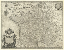
Extraordinary wall map of France, Belgium and Western Switzerland, along with Zeeland, Brabant, Limbourg, Gelderland and Pomerania, published by Aaron Arrowsmith in London.
This remarkable work is based upon the national surveys conducted by the Cassini Family, x and y.
For France, the map relies primarily on the work of César-François Cassini (Cassini III) and his son Jean-Dominique Cassini (Cassini IV). The Cassini family were a dynasty of Italian-French astronomers, geodesists, and cartographers, famous for their work in the Paris Observatory. Their work included the the first topographic map of an entire country based on triangulation, and National Atlas of France, another ambitious project that began under the direction of King Louis XV.
For Belgium, Arrowsmith relies upon the 275 sheet map of the Austrian Netherlands by Joseph de Ferraris, created between 1770 and 1778, prepared for Prince Charles Alexander of Lorraine. The Ferraris map is the first systematic, large scale mapping of modern-day Belgium and parts of Western Europe.
The final contributor note is Johann Heinrich Weiss. The Atlas Suisse, published between 1786 and 1802, was produced for Johann Rudolf Meyer by Johann Heinrich Weiss, and is considered the oldest map series based upon scientific survey and covering the whole of Switzerland.
In 1786, the industrialist Johann Rudolf Meyer decided to create a map of Switzerland at his own expense. He engaged a geometer, Johann Heinrich Weiss of Strasbourg. The foundations for Meyer's map were baseline measurements by the scientist Johann Georg Tralles and landscape relief modelling by Joachim Eugen Müller, after which Weiss drew the map. The final result was a map of Switzerland 16 sheets and an overview map, which would endur for nearly a half century as the most important map of Switzerland, until the appearance of Dufour Map (1845-1865).
Rarity
The map is extremely rare.
OCLC locates 2 examples: British Library and University of Oxford. The Library of Congress also holds an example, bound into a composite atlas of 11 Arrowsmith wall maps.
RBH locates only this example at auction (2023).
The Arrowsmiths were a cartographic dynasty which operated from the late-eighteenth century to the mid-nineteenth. The family business was founded by Aaron Arrowsmith (1750-1823), who was renowned for carefully prepared and meticulously updated maps, globes, and charts. He created many maps that covered multiple sheets and which were massive in total size. His spare yet exacting style was recognized around the world and mapmakers from other countries, especially the young country of the United States, sought his maps and charts as exemplars for their own work.
Aaron Arrowsmith was born in County Durham in 1750. He came to London for work around 1770, where he found employment as a surveyor for the city’s mapmakers. By 1790, he had set up his own shop which specialized in general charts. Arrowsmith had five premises in his career, most of which were located on or near Soho Square, a neighborhood the led him to rub shoulders with the likes of Joseph Banks, the naturalist, and Matthew Flinders, the hydrographer.
Through his business ties and employment at the Hydrographic Office, Arrowsmith made other important relationships with Alexander Dalrymple, the Hudson’s Bay Company, and others entities. In 1810 he became Hydrographer to the Prince of Wales and, in 1820, Hydrographer to the King.
Aaron Arrowsmith died in 1823, whereby the business and title of Hydrographer to the King passed to his sons, Aaron and Samuel, and, later, his nephew, John. Aaron Jr. (1802-1854) was a founder member of the Royal Geographical Society (RGS) and left the family business in 1832; instead, he enrolled at Oxford to study to become a minister. Samuel (1805-1839) joined Aaron as a partner in the business and they traded together until Aaron left for the ministry. Samuel died at age 34 in 1839; his brother presided over his funeral. The remaining stock and copper plates were bought at auction by John Arrowsmith, their cousin.
John (1790-1873) operated his own independent business after his uncle, Aaron Arrowsmith Sr., died. After 1839, John moved into the Soho premises of his uncle and cousins. John enjoyed considerable recognition in the geography and exploration community. Like Aaron Jr., John was a founder member of the RGS and would serve as its unofficial cartographer for 43 years. Several geographical features in Australia and Canada are named after him. He carried the title Hydrographer to Queen Victoria. He died in 1873 and the majority of his stock was eventually bought by Edward Stanford, who co-founded Stanford’s map shop, which is still open in Covent Garden, London today.
![(Southeast Asia) [Unpublished Manuscript Sailing Directions from Europe to China by a French Navigational Officer]](https://storage.googleapis.com/raremaps/img/small/90507.jpg)
![[Liege] Leodium. Civitatis Leodiensis Genuina Delineatio . . .](https://storage.googleapis.com/raremaps/img/small/89303.jpg)
![[Grenoble 1968 Winter Olympics] L'Alpe D'Huez France - Isere](https://storage.googleapis.com/raremaps/img/small/84340.jpg)