


|
||

|

|
|

|
Stock# 99232
Description
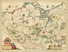
Rare first state of Claes Janszoon Visscher's map of northern Germany and northwestern Poland, first published in 1630.
Engraved by Abraham Goos and published by Claes Jansz. Visscher, this detailed map offers a comprehensive view of the regions of Brandenburg, Mecklenburg, and Pomerania, along with parts of what is now western Poland.
The map includes inset views of four towns: Stettin (now Szczecin in Poland), Rostock, Stralsund, and Frankfurt an der Oder.
Condition Description
Original hand color. Trimmed to neatline and mounted on paper.
Reference
Campbell, Claes Jansz. Visscher: A Hundred Maps Described (MCS No. 46), Nr. 18. Bott, 519.
![[ Bishopric of Osnabrück ] Osnabrugensis Episcopatus Auctore Ionane Gigante](https://storage.googleapis.com/raremaps/img/small/64343op.jpg)