


|
||

|

|
|

|
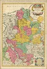
Fine old color example of this fine regional map of the Duchies of Jülich, Cleves, Berg, as well as the Counties of Mark and Ravensberg.
Oriented with west at the top, the features an elaborate heraldic cartouche and two portraits in the upper corners, Emperor Rudolf II to the left and Margrave Ernst of Brandenburg to the right.
The secondary map of the County of Ravensberg.
Includes an early Blaeu signature: "T'Amsterdam gedruckt by Hessel Gerritz z. ende men vindze te coop bij Willem Ians z. opt Water In de vergulde Sonnewyser".
Willem Janszoon Blaeu (1571-1638) was a prominent Dutch geographer and publisher. Born the son of a herring merchant, Blaeu chose not fish but mathematics and astronomy for his focus. He studied with the famous Danish astronomer Tycho Brahe, with whom he honed his instrument and globe making skills. Blaeu set up shop in Amsterdam, where he sold instruments and globes, published maps, and edited the works of intellectuals like Descartes and Hugo Grotius. In 1635, he released his atlas, Theatrum Orbis Terrarum, sive, Atlas novus.
Willem died in 1638. He had two sons, Cornelis (1610-1648) and Joan (1596-1673). Joan trained as a lawyer, but joined his father’s business rather than practice. After his father’s death, the brothers took over their father’s shop and Joan took on his work as hydrographer to the Dutch East India Company. Later in life, Joan would modify and greatly expand his father’s Atlas novus, eventually releasing his masterpiece, the Atlas maior, between 1662 and 1672.
![[ Brandenburg & Pomerania ] Tabula Electoratus Brandenburgici, Meckelenburgi et Maximae Partis Pomeraniae . . . 1630](https://storage.googleapis.com/raremaps/img/small/99232.jpg)
![Thietmarsiae, Holsaticae Regionis Partis Typus [with] Oldenburg Comit.](https://storage.googleapis.com/raremaps/img/small/83583.jpg)
![[Rhine River] Nova Totius Rheni Descriptio ex celeberrimis et varijs Autoribus, in unam tabulam redacta . . . 1672](https://storage.googleapis.com/raremaps/img/small/62395.jpg)