


|
||

|

|
|

|
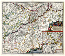
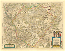
Fine old color example of the Bishoprick of Paderborn, published in Amsterdam by Blaeu.
The map is centered on Paderborn and includes multiple coats of arms of the different regions illustrated.
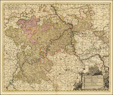
Paderborn, the episcopal see, was a center of religious and administrative importance. Other notable cities depicted include Warburg, Büren, and Lippstadt. Warburg, with its strategic location, was often embroiled in the military campaigns of the Thirty Years' War. Büren, known for its agricultural and trade activities, played a role in the regional economy. Lippstadt, a town with a history of allegiance shifts during the war, reflected the complex political landscape of the time.
The Bishopric of Paderborn, a principal ecclesiastical territory in the Holy Roman Empire, was situated in what is now modern-day Germany. The map illustrates the region during the Thirty Years' War (1618-1648), a conflict that ravaged much of Central Europe, including the territories depicted in this map. The war, fueled by religious tensions between Catholic and Protestant states within the Empire, had profound political, social, and economic consequences for regions such as Paderborn.
During this period, several key treaties and events impacted the region. The Peace of Westphalia, which concluded the Thirty Years' War in 1648, was particularly significant. The Peace of Westphalia reshaped the political landscape of the Holy Roman Empire, including the Bishopric of Paderborn. This treaty marked the end of Catholic hegemony in the Empire and recognized the sovereignty of its constituent states, leading to a more balanced religious and political order.
Willem Janszoon Blaeu (1571-1638) was a prominent Dutch geographer and publisher. Born the son of a herring merchant, Blaeu chose not fish but mathematics and astronomy for his focus. He studied with the famous Danish astronomer Tycho Brahe, with whom he honed his instrument and globe making skills. Blaeu set up shop in Amsterdam, where he sold instruments and globes, published maps, and edited the works of intellectuals like Descartes and Hugo Grotius. In 1635, he released his atlas, Theatrum Orbis Terrarum, sive, Atlas novus.
Willem died in 1638. He had two sons, Cornelis (1610-1648) and Joan (1596-1673). Joan trained as a lawyer, but joined his father’s business rather than practice. After his father’s death, the brothers took over their father’s shop and Joan took on his work as hydrographer to the Dutch East India Company. Later in life, Joan would modify and greatly expand his father’s Atlas novus, eventually releasing his masterpiece, the Atlas maior, between 1662 and 1672.
![(First state!) [ Rhine River Valley ] Quarta Rheni et IX Nova Tabula](https://storage.googleapis.com/raremaps/img/small/95910.jpg)