


|
||

|

|
|

|
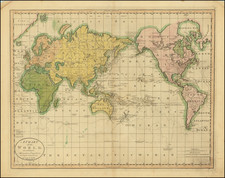
The Most Detailed World Map of the First Quarter of the 19th Century.
This 1825 wall map by Christian Gottlieb Reichard is a tour-de-force depiction of the world reflecting the geographical knowledge and discoveries up to 1824. It was published by Friedrich Campe in Nuremberg as a significant update to Aaron Arrowsmith's Chart of the World on Mercator's Projection, Exhibiting all the New Discoveries to the present Time (published between 1790 and 1811), and incorporates dozens more explorations and a much more detailed representation of global topography unseen in Arrowsmith's maps.
An Heir to Arrowsmith's Map
The map is readily identifiable with Arrowsmith's from its shared inclusion of the scale showing 100 leagues upon every parallel of latitude from the Equator to the 80th degree. This table is intended to help readers calculate the distance between two points with only the latitude of the points and the bearing between them. It is intended to help to overcome the level of distortion inherent within a Mercator projection.
While the broad geographic outlines are similar, a close examination shows that Reichard's exacting map puts Arrowsmith's usually unimpeachable accuracy to shame. Reichard's coasts, mountains, and rivers are more advanced and more precisely delineated everywhere.
This map is a testament to the era's rapid geographical discoveries and advancements in cartography. During the early 19th century, exploration was at its zenith, with consecutive voyages expanding the world's geographical understanding. This period witnessed the demystification of many previously unknown territories. On this map only the interiors of Africa, Arabia, Australia, northern Canada, the American Southwest, and Greenland still hold mystery.
Reichard's map lists and tracks the routes of 46 significant exploratory voyages, dating from Columbus's journeys in 1492 and 1493 to Parry's expeditions between 1819 and 1824. While rendering explorer's tracks was not unusual for world maps from this period, Reichard has gone well beyond the usual half-dozen or so. The map provides a visual record of the paths taken by explorers like Vasco de Gama, Magellan, Tasman, Cook, and lesser-known ones such as Pickertsgill, Phipps, Pleurieu, etc.
The only comparable map of a similar scale from this period was another Arrowsmith heir, Adrien Hubert Brue's double-hemisphere Mappe Monde en deux Hemispheres...
Rarity
OCLC records six examples of this edition in German institutions and examples at the BNF, National Library of Poland, and another is at the National Library of the Czech Republic; it also records a map of a slightly different title, but probably the same edition, at the British Library.
From OCLC, it appears that editions were published in 1818, 1822, 1825, and 1839.
Christian Gottlieb Reichard (1758-1837) was a German cartographer. Reichard studied law in Leipzig and found work as a town clerk in Bad Lobenstein. He had great personal interest in geography, history, and cartography, hobbies which gained him more renown than law. However, even after he began making maps, he continued working his clerk job, which gave him the financial stability to support his family.
Reichard is best known for his work on his Atlas des Ganzen Erdkreises in der Central Projection (Atlas of the Whole World in the Central Projection) in 1803 and the Orbis terrarum antiquus (Atlas of the Ancient World) of 1824. He is also likely the first published cartographer to adopt the Albers conic projection, in his map Die Vereinigten Staaten von Nord-America, nach den sichersten Bestimmungen, neuesten Nachrichten und Charten, in der Alber’schen Projection entworfen, (The United States of North America, after the safest regulations, latest news and charts, designed in the Alberian projection), where he references the Albers projection by name.
Reichard’s work was known by his contemporaries as highly accurate, and in fact this descriptor still holds up today. This accuracy, along with his skill, made him very publishable, and he worked on a number of atlases with other cartographers, such as Steiler’s Handatlas. Reichard’s style is simple but includes great detail, making his maps both recognizable at a glance and engaging upon deeper study.
![Stereographic Projection [and] Orthographic Projection on the Plane of the Equator](https://storage.googleapis.com/raremaps/img/small/64905.jpg)
