


|
||

|

|
|

|
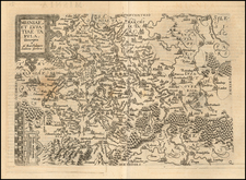
Fine old color example Blaeu's mapof the County of Nassau.
The map includes the towns of Nassau, Dietz, Siegen and Herborn.
At the turn of the century, Nassau was a patchwork of territories under the nominal control of the Holy Roman Emperor. Governed by various branches of the House of Nassau, the region was predominantly Protestant, having been influenced by the Reformation. The religious tension that had been building across the Empire found a reflection in Nassau, where the local rulers often navigated the treacherous waters between Catholic imperatives and Protestant resistance.
The outbreak of the Thirty Years' War in 1618 was a turning point for Nassovia. This devastating conflict, which eventually embroiled most of Europe, began as a battle between Catholic and Protestant states within the Holy Roman Empire but quickly morphed into a more extensive power struggle involving several European powers. Nassovia Comitatus, strategically positioned and fragmented among influential noble families, became a stage for military engagements and political maneuvers.
Willem Janszoon Blaeu (1571-1638) was a prominent Dutch geographer and publisher. Born the son of a herring merchant, Blaeu chose not fish but mathematics and astronomy for his focus. He studied with the famous Danish astronomer Tycho Brahe, with whom he honed his instrument and globe making skills. Blaeu set up shop in Amsterdam, where he sold instruments and globes, published maps, and edited the works of intellectuals like Descartes and Hugo Grotius. In 1635, he released his atlas, Theatrum Orbis Terrarum, sive, Atlas novus.
Willem died in 1638. He had two sons, Cornelis (1610-1648) and Joan (1596-1673). Joan trained as a lawyer, but joined his father’s business rather than practice. After his father’s death, the brothers took over their father’s shop and Joan took on his work as hydrographer to the Dutch East India Company. Later in life, Joan would modify and greatly expand his father’s Atlas novus, eventually releasing his masterpiece, the Atlas maior, between 1662 and 1672.
![[ Duchy of Jülich] Iuliacensis Ducatus](https://storage.googleapis.com/raremaps/img/small/50126.jpg)
![Buchaviae, sive Fuldensis Ditionis Typus. Wolfgango Regrwill auctore. 1574 [with] Waldeccensis Comitatus Descriptio Accuratissima](https://storage.googleapis.com/raremaps/img/small/84071.jpg)
![[Theater of the War of Polish Succession] [Geographisches Kriegs Theatrum der Kayserlichen und Reichs - wie auch Frantzösischen Armee am Rhein-Strom ... alle Marchen beider Armeen, so Anno 1734 geschehen, angezeiget worden]](https://storage.googleapis.com/raremaps/img/small/67037.jpg)