|
||

|

|
|

|
"Here About Mr. Dobbs Supposes A Passage to the South Sea"
Extensively Annotated in an Early English Hand -- Documenting the First Middleton Expedition in Search of the Northwest Passage
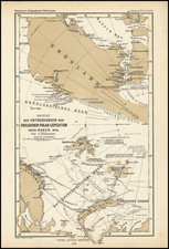
Unique annotated example of De Wit's map of Hudson Bay, Baffin Bay, Button Bay, Davis Straits and contiguous parts of the coastline of Canada and Greenland.
The printed map, De Wit's map of the Canadian Arctic regions, was a staple of the 17th Century, which was still being published by the Ottens family in the 1740s. Based upon the annotations, as discussed in greater detail below, it is possible that this map was annotated as part of the famed Dobbs-Middleton Controversy relating to the search for the northwest passage, possibly by one of the principal participants or otherwise in connection with the construction of the two primary maps that emerged from the 1741 Middleton expedition which launched the controversy. The map also lacks any reference to Chesterfield Inlet, discovered on a subsequent expedition in 1746-47 sponsored by Arthur Dobbs, strongly suggesting that the annotations pre-date the return of the 1746-47 voyage.
Extensively annotated in English, the annotations related almost entirely to the expedition of Christopher Middleton in search of the Northwest Passage in 1741. As discussed in greater detail below, the annotations bear a remarkable similarity to the details set forth in John Wigate's mapping of the expedition. In 1741, Middleton, a distinguished captain with the Hudson’s Bay Company and a member of the Royal Society, quit the Company and accepted a commission in the Navy to lead an expedition sponsored by Arthur Dobbs (future Governor of North Carolina) to find the northwest passage. Dobbs was convinced that the Hudson's Bay Company had failed in it's duty to search for the northwest passage and sought to annul the trade monopoly granted to the HBC in the region. After failing to find a route to the Pacific, Middleton returned, convinced that no passage existed. Dobbs disagreed, believing Middleton's former affiliation with Hudson's Bay Company had led him to intentionally fail in his efforts, which led to a multi-year battle between the two, memorialized in subsequent maps and pamphlets, which is generally referred to as the Dobbs-Middleton controversy.
Either independently or at Dobbs’ instigation, three members of Middleton’s crew (John Wigate and Edward Thompson) wrote letters asserting Middleton had conspired with the Company to hide the existence of a passage to the Pacific and were later supported by , Lieutenant John Rankin and William Moor.
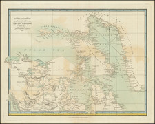
As a mapmaker, Wigate assisted in the preparation of A New Map of Part of North America . . . (London, 1743), which sets forth in detail the results of the first voyage and a second map entitled To Arthur Dobbs Esquire This Chart of the Seas, Straits &c. thro' which his Majesty's Sloop Furnace pass'd for discovering a Passage from Hudson's Bay to the south Sea. . . , published by John Bowles in London in 1746.
The annotations are drawn on the first state of De Wit's map, part of a series of charts of the region that began with Van Loon's map of 1668. The basic template remained Hessel Gerritz's printed version of Henry Hudson's charts, published in Amsterdam in 1612. Over time, the cartography was improved by Jansson, Blaeu and Sanson, from which the present depiction has been composed. Fredertick De Wit (1630-1706) was by the time this chart was published the leading Dutch mapmaker. His chart came out at a critical juncture, for in 1670, the English had founded the Hudson's Bay Company, which would dominate commerce in the region for the next 250 years. De Wit's map remained the authoritative printed chart of these subarctic waters for the remainder of the century.
The Dobbs-Middleton Maps
The first map noted above, is attributed to "Joseph la France a French Canadese Indian, who travailed thro those countries and lakes for 3 years from 1739 to 1742." Dobbs claimed that he received the information for the map from Joseph La France, was a Métis coureur de bois, who had traveled and lived in the area between 1739 and 1742, and had come to London in 1742 after trading at the York Factor on Hudson Bay. La France reportedly supplied crude maps as well as much information concerning the geography and demographics of the region to Dobbs and others.
While La France is described as the maker of the map, the actual details would undoubtedly come from others. The probably source, John Wigate (biography below), was the ship's clerk on board the Furnace and, as noted below, credited with the production of the 1746 map entitled This Chart of the Seas, Straits &c. thro' which his Majesty's Sloop Furnace pass'd for discovering a Passage from Hudson's Bay to the south Sea . . . , published by John Bowles. Wigate would seem to be the most likely candidate.
Annotations on The De Wit Map -- Dobbs Middleton Controversy
With the exception of a few of the annotations, the vast majority relate directly to the 1741-42 Middleton Expedition and would seem to have been created with an absence of knowledge of the subsequent voyages undertaken as part of the Dobbs-Middleton Controversy. Prior to the subsequent voyage, under Captain's Francis Smith and William Moor in 1746-47, and financed by Dobbs, the map lacks any reference to Chesterfield Inlet, discovered on this second voyage.
The comparison between the place names shown on the present map and the La France map is quite remarkable. While the present map does not include a specific use of the name "Repulse Bay," virtually every other name on the La France map appears on the manuscript map, including a number of place names not shown on the La France map. It is also noteworthy that a number of places on both maps are transposed, including Whale Cove, Lovegrove Cove (or Opening) and The Welcome.
The construction of Wager Strait also differs significantly between the two maps, with two outlets to the north in the manuscript annotations on the present map, versus only one to the north on the La France map.
Two of the notes, in particular, strongly suggest a contemporary connection to the controversy:
- here abt. Mr. Dobbs supposes a passage to the South Sea
- Deer Sound. here Capt. Middleton found Whales 1742. nor 'tis genly suppos'd yr is a pssage into the S. Sea.
We suggest that there is a meaningful possibility that the notes written here were made by John Wigate or another person intimately involved in the Dobbs-Middleton controversy. It is similarly possible that this map was used to inform the making of the 1742 La France map or the 1746 Wigate/Bowles map. A closer comparison of the handwriting is in order. The details and specificity strongly suggest that the annotations are contemporary to the controversy and made by someone focuses almost exclusively on the dispute. Certainly, the annotations would have been unlikely after the publication of the 1748 Henry Ellis map of the region. Only the Greenland related annotations are outliers.
Full Transcription of Annotations (those in bold are not on the La France map):
- Mr. [Hans] Egede a Danish Missionary, who travelled all the E[ast] Coast says, that it is one continued continent from Capt Farewell, & only Bays without any passage thro'
- l'Esperance a Danish Settl
- Cape Farewell
- Smith's Isl.
- [Martyn Forbischers Straet] 1576
- Deer Sound. here Capt. Middleton found Whales 1742. no 'tis genly suppos'd yr is a pssage into the S. Sea.
- here abt. Mr. Dobbs supposes a passage to the South Sea
- Cape Frigid
- [Ne Ultra] or Sir Thom[a]s Roe's Welcome
- Savage Sound
- Wager's Straits [Sir Charls Wager, First Lord of the Admiralty, 1733-1742, died 1743).
- Cape Hope
- Cape Dobbs
- Cape Fullerton
- prince of Wale's port
- Churchill R. & Co. & Fort long. from Londn. 95. lat. 59.
- Rankins Inlet
- Marble Isl.
- Whale Cove
- Cape Whalebone point
- Nelson River
- The Great Fork?
- Hayes Isl.
- New Severn River & Fort [discovered by Capt. Thomas James in 1631; HBC Fort established in 1685, burned in 1689 to avoid capture by the French and re-estabished as a British Trading Post in 1759]
- York Fort
- Hayes River.
- Pachegoia Lake
- Albany R. & Fort
- Moose R. [and] Fort
- Rupert's R. & Fort
- Nodway [Nottaway] River
- Slude R. [and] Fort
- [Baffin's Bay] 1616
- [Cary's] Swan's Nest
Hans Egede
The annotation references Hans Egede, also known as the Apostle of Greenland, refers to a Danish Missionary, who established the Bergen Greenland Company, as means of searching for old Norse Settlements in Greenland and to establish a colony. Beginning in 1721, he set out for the region, landing at Nuup Kangerlua and establishing Hope Colony (Haabets Colonie) with the erection of a portable house on Kangeq Island. Egede remained most of the time in the region for the next 14+ years, with his son Pou carrying on his Missionary work. A supply ship in 1733 brought three missionaries and news that the king had granted 2,000 rixdollars a year to establish a new company for the colony under Jacob Sørensen Severin, whose name can also be found written on the present map. The Greenland monopoly ran from 1733 and was renewed in 1740.
John Wigate
The following biographical information appears in the Dictionary of Canadian Biography for John Wigate
John Wigate was appointed in the spring of 1741 as clerk of the naval sloop Furnace, which sailed in June to Hudson Bay under the command of Christopher Middleton in search of a northwest passage. After the failure of the expedition Wigate became associated with his fellow crew-members Edward Thompson and John Rankin in the campaign organized by Arthur Dobbs to discredit Middleton’s handling of the expedition. Like the others, Wigate was ready to swear at the admiralty hearings of 1743 that Middleton had falsified his journal and chart of the voyage, and he was perhaps the more ready to do so since nine months after the expedition’s return in the autumn of 1742 Wigate had still received no pay as a result of Middleton’s insistence that he must first deliver up the accounts of the Furnace. Wigate’s only distinctive contribution to the controversy over the Middleton expedition was his apparent responsibility for a map issued under his name in 1746 (probably to coincide with the sailing of the private discovery expedition organized by Dobbs). The map summed up in vivid cartographical form Dobbs’ main arguments. It showed the west coast of Hudson Bay broken by unexplored inlets, notably Rankin Inlet; and the Wager was firmly marked “Wager Strait,” open to the west, and with a tide flowing through it from that direction. Whether Wigate did more than lend his name to Dobbs for the map is questionable; but in any case the honour of composition was a doubtful one, for within a year of the map’s publication William Moor's expedition discovered that both Rankin Inlet and the Wager were closed bays, as Middleton had always maintained.
Closing Notes
The direct connection of the present annotations to a principal involved in the Dobbs Middleton controversy is of course based upon a fair amount of circumstantial evidence and speculation.
Nevertheless, the map is clearly informed by the intimate details of the first Middleton expedition and would seem unlikely to have been created in such meticulous detail except in the window of time between the first expedition and the Henry Ellis expedition of 1746-47.
Further research is definitely warranted.
We join with this offering, the notes of a prior owner.
De Wit (1629 ca.-1706) was a mapmaker and mapseller who was born in Gouda but who worked and died in Amsterdam. He moved to the city in 1648, where he opened a printing operation under the name of The Three Crabs; later, he changed the name of his shop to The White Chart. From the 1660s onward, he published atlases with a variety of maps; he is best known for these atlases and his Dutch town maps. After Frederik’s death in 1706, his wife Maria ran the shop for four years before selling it. Their son, Franciscus, was a stockfish merchant and had no interest in the map shop. At the auction to liquidate the de Wit stock, most of the plates went to Pieter Mortier, whose firm eventually became Covens & Mortier, one of the biggest cartography houses of the eighteenth century.