|
||

|

|
|

|
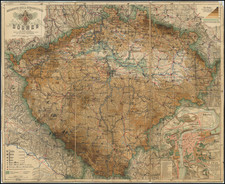
Fine old color example of this decorative antique engraved map of Bohemia centered on Prague, by Willem Janszoon Blaeu.
The map emphasizes rivers, towns and forests in the region. The map notes that "Names that have a triangle at the end are Bohemian."
The following symbols appear:
-
Civitas Regia libera - The Royal city, indicated by a crown symbol, for Prague
-
Oppidum Regis Bohemiae - This refers to a town under the jurisdiction of the King of Bohemia
-
Oppida Baronum et Nob. - Towns belonging to barons and nobility
-
Pagus - A term that can refer to a rural district or village.
-
Arx - This denotes a fortress or a castle.
-
Castellum - A smaller castle or fort.
-
Monasterium - A monastery
-
Oppidum cum Arce - A town with a fortress
-
Pagus cum Arce - A rural district or village with a fortress, which would be denoted by a combination of the symbols for "Pagus" and "Arx".
-
Fodinae aur., argent., stanni, ferri - Mines for gold (aurum), silver (argentum), tin (stannum), and iron (ferrum), each represented by a symbol. The sun symbol often represents gold, a crescent may represent silver, and other icons for tin and iron.
-
Thermae - Baths or hot springs
-
Officina Vitriaria - A glassworks or glassblower's workshop
Willem Janszoon Blaeu (1571-1638) was a prominent Dutch geographer and publisher. Born the son of a herring merchant, Blaeu chose not fish but mathematics and astronomy for his focus. He studied with the famous Danish astronomer Tycho Brahe, with whom he honed his instrument and globe making skills. Blaeu set up shop in Amsterdam, where he sold instruments and globes, published maps, and edited the works of intellectuals like Descartes and Hugo Grotius. In 1635, he released his atlas, Theatrum Orbis Terrarum, sive, Atlas novus.
Willem died in 1638. He had two sons, Cornelis (1610-1648) and Joan (1596-1673). Joan trained as a lawyer, but joined his father’s business rather than practice. After his father’s death, the brothers took over their father’s shop and Joan took on his work as hydrographer to the Dutch East India Company. Later in life, Joan would modify and greatly expand his father’s Atlas novus, eventually releasing his masterpiece, the Atlas maior, between 1662 and 1672.
![[ Holy Roman Empire ] A Newe Mape of Germany Newly Augmented by Iohn Speed Ano Dom: 1626](https://storage.googleapis.com/raremaps/img/small/68482.jpg)
![(Czech Settlement in Manitoba) Mapa státu: Manitoba a kanádského Severozápadu s rozlíčnym železničním spojením a českymi a německymi osady | Manitobe Nove Cechy Hohenlohe-Langeburg [State Map: Manitoba and the Canadian Northwest with railway connections, including Czech and German settlements | Manitoba, New Cezchia]](https://storage.googleapis.com/raremaps/img/small/88274.jpg)