


|
||

|

|
|

|
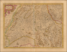
The Rhaetia-map -- The First Modern Map of the Canton of Graubuden.
Fantastic old color example of this Claesz Janzoon Visscher edition of the first modern map of the Canton of Graubuden, originally published by Fortunat Sprecher von Berneck (1585-1647) and Philipp Cluverius (1580-1623).
The map was originally published by Sprecher von Berneck and Philipp Cluverius in 1618. In 1621, the map was re-issued by Nicholaes Van Geelkercken, with the poem below the title cartouche replaced by a new title "Karte vande Grisons ende Veltolina."
The final edition of the map, re-issued in 1625 by CJ Visscher, includes a revised title and the date of 1625. The two decorative elements in the lower left have been replaced with a scale of miles and additional cartographic details. Visscher has also includes additional details, most notably around Lago di Como.
The Sprecher von Berneck-Cluverius map would later be copied by a number of mapmakers, including Hondius, Blaeu and Jansson.
Rarity
The map is very rare on the market. This is the first example we have ever seen.
![[ Basel, Switzerland ] Basilea](https://storage.googleapis.com/raremaps/img/small/96903.jpg)
![[Bern, Switzerland] Plan von der Stadt und dem Stadtbezirk Bern. Mit hoher Bewilligung des Tit. Stadt-Raths von Bern, aus den in Seinen Archiven liegenden geometr. Grundrissen ausgezogen, reduciert, gezeichnet, und zum Theil aufgenommen Ao. 1809 . . . Ao. 1811](https://storage.googleapis.com/raremaps/img/small/90479.jpg)
![[ Zurich Region / Switzerland ] Delineatio Pagi Tigurini ex observationibus recentissimis et accuratissimis Accedit serosim in tabella Dominium Sax et Forsteck . . .](https://storage.googleapis.com/raremaps/img/small/103389.jpg)