|
||

|

|
|

|
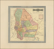
Finely drawn map of Mexico, California and Texas, modeled after a rare early edition of John Tallis's iconic map of the region.
Issued shortly after the Mexican War and the California Gold Rush, the map shows the region prior to the Compromise of 1850, which would define the boundaries between Texas and New Mexico Territory.
Decorative regional map of Texas, California, and the Southwest, featuring Texas in its Republic configuration, with stovepipe reaching to Wyoming and Colorado. This map was published in London by John Tallis, the last great decorative mapmaker.
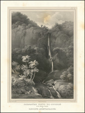
The artist has drawn the second edition of the map, which includes a gold washing vignette not included in the first edition, representing the newfound global interest in the Californian gold rush. Two other vignettes show archeological ruins in the Yucatan and "Mexican peasantry."
Upper California is shown with the gold regions highlighted in gold, Arizona has a pre-Gadsden border with Mexico, and a host of other contemporary details are visible such as a massive Oregon. Numerous Indian tribes named throughout the Southwest. Early routes through Texas and the West are shown. The map includes a number of forts and outposts in Texas and Upper California.
The map is a significant enlargement of the printed map, drawn with a fine hand.
The printed version of the map can be found here.
![[ Original Artwork - 37 Hand Drawn Maps By Norton Allen For Desert Magazine ]](https://storage.googleapis.com/raremaps/img/small/99899.jpg)
![(Aztec Tribute List) [Original watercolor showing tribute items paid to the Aztecs by subject towns] Mendoza Col. part 1s Lorenzana, Aglio 1, Vol 22...](https://storage.googleapis.com/raremaps/img/small/102321.jpg)