|
||

|

|
|

|
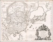
Nice detailed map of the region, with insets of the regions around Shanghai, Tokyo and Canton.
The map includes a legend categorizing various territories in China, Korea, and Japan according to their political divisions and European colonial possessions at the time. This legend offers an understanding of the geopolitical landscape of East Asia in the late 19th century, as well as the extent of European influence and control in the region at that time. The legend uses color codes to distinguish between different political and territorial entities:
-
China (Tschung-kue):
- Yellow represents lands under Chinese sovereignty.
- Green indicates Mongolian regions.
- Pink refers to the Manchuria area.
- Blue with diagonal lines denotes Russian territory.
- Purple stands for English possessions.
- Brown represents Portuguese possessions.
- Light green signifies independent Malay states.
-
Korea (Tso sjon), labeled as "Politische Eintheilung" (Political Division), lists eight regions or districts:
- Li Hsien kjang to
- Pjong an to
- Hwang hai to
- Hang won to
- Hjong kai to
- Tsjung tsjöng to
- Kjö la to
- Kjong sjang to
-
Japan (Dai nippon), also labeled with "Politische Eintheilung," lists eight regions, likely prefectures:
- Nao san too
- Hoh rok too
- Too kai too
- Ki nai
- San in too
- San joo too
- Nan kai too (Sikok)
- Sai kai too (Siu kai)
The bottom note states that "with underlined names are the names of the places opened to Europeans and other foreigners for trade," hinting at the ports that were part of international trade agreements, such as Treaty Ports in China after the Opium Wars.
![[Heightened with Gold!] Paskaerte Zynde t'Oosterdeel Van Oost Indien, met alle de Eylanden daer ontrendt geleegen van C. Comorin tota aen Iapan](https://storage.googleapis.com/raremaps/img/small/83769.jpg)
![Carte des nouvelles decouvertes dresseee par Phil. Buache… [with] Extrait d'une Carte Japonoise de l'Univers apportee en Europe par Kaempfer . . . [Bay of the West]](https://storage.googleapis.com/raremaps/img/small/84038.jpg)