|
||

|

|
|

|
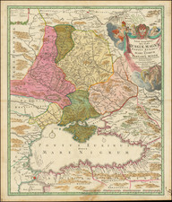
Rare separately published map of Poland and parts of the Lithuania, Latvia, Belarus and Ukraine published by Artaria & Company in Vienna in 1831.
The map shows the region in meticulous detail, with major roads, towns, rivers, lakes and mountains meticulously shown.
The title of the map transates as follows: "Map of Poland according to its current division into the new Kingdom of Poland, the remaining Russian possessions, the Prussian Grand Duchy of Posen, the Republic of Krakow, and the Kingdom of Galicia."
This map offers a meticulously detailed representation of Poland's political landscape as reconstituted by the powers of 19th-century Europe. The map comes six decadse after the first of the partitions of Poland, conducted in 1772, 1793, and 1795 by the empires of Russia, Prussia, and Austria, which eradicated the sovereign Polish-Lithuanian Commonwealth and redrew the map of Central Europe. This cartographic artifact reflects the outcomes of these partitions and subsequent treatiesincluding the changes following Napoleon's initial conquest of the region and subsequent Congress of Vienna:
-
The Kingdom of Poland (Congress Poland), represented in pink, was established by the Congress of Vienna in 1815. This entity was an autonomous monarchy in personal union with the Russian Empire, under the constitution granted by the Tsar.
-
The other Russian territories, shown in green, were incorporated into the Russian Empire through the successive partitions and confirmed by the Congress of Vienna, significantly expanding the Tsar's dominion.
-
The Prussian Grand Duchy of Posen, marked in blue, was a result of the treaties concluding the Napoleonic Wars, where Prussia gained this territory, formally integrating it after the Congress of Vienna.
-
The Republic of Krakow, indicated in yellow, established by the Treaty of Vienna in 1815, was a semi-independent city-state, surrounded by three partitioning powers, intended to be a symbol of Polish independence.
-
The Kingdom of Galicia, colored in orange, was annexed by Austria during the first partition and was further consolidated after the final partition of Poland.
-
The Kingdom of Prussia, in dark yellow, showcases the land retained by Prussia post the partitions and subsequent treaties.
By 1831, Poland's political reality was a fragmented existence under the sway of neighboring empires. The map's key, "Zeichen Erklärung," is not merely a legend but a historical document, distilling complex treaties and political changes into a visual guide.
The status quo of Poland's governance in 1831 was defined by the administrative structures imposed by the partitioning powers. The Congress Poland possessed a semblance of autonomy under the Tsar's constitutional framework, while other regions were integrated into the administrative systems of the respective empires, each reflecting varying degrees of assimilation and control. This map, therefore, not only outlines the territorial divisions but also implicitly the varied experiences of governance under which the Polish people lived.