|
||

|

|
|

|
"M. Delesse Deserves the Hearty Thanks of Every Student of American Physical Geography and Geology"
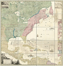
Rare loose set of separately published maps, intended to accompany French Geologist Achille Delesse's Lithologie du Fond des Mers . . . , published in Paris in 1871.
The present set of maps, were prepared by Achille Delesse's to illustrate his extremely rare 2 volume Lithologie des mers de France et des mers principales du globe. The atlas volume is extremely rare, as is the second volume of Delesse's book.
Elected to the American Philosophical Society in 1863, Delesse's important work was reviewed by the APS in 1876, with excerpts below:
Mr. Lesley added his testimony to the great value of the work of M. Delesse, of which Prof. Frazer had spoken:
He hoped that the Lithologie du Fond des Mers would be translated into English, and the magnificent maps accompanying it republished for the use of American geologists. If only the one map of the American continent and its enclosing waterbeds were published, showing by colors the different sediments which issue from our rivers, and are distributed by tidal currents along our coasts, it would be a most valuable addition to our handbooks of geology. Many of the problems of erosion and sedimentation in Mesozoic and Kainozoic times, are plainly helped to solution by this map.
One of the most striking features is the contrast between the sediment in front of the coast from Maine to Alabama, and that of the sediment filling the St. Lawrence Gulf, and tapering southwards to a point opposite Norfolk. The former sediment fills the in-shore angle of the Gulf of Mexico, in front of Pensacola; the latter is repeated as an outside belt, stretching from the mouth of the Mississippi to a point in front of Havana.
It is easy to see the cause of the difference. The inside sediment descends the rivers which drain the siliceous and feldspathic mountains of New England, New York and Pennsylvania, Virginia, the Carolinas and Georgia, composed of Azoic and Palaeozoic formations. The outside sediment descends the St. Lawrence and the Mississippi, and represents the drainage of the argillaceous and calcareous interior of the continent, composed of the Sub-carboniferous limestone formations east of the Mississippi, and of the broad stretches of Cretaceous and Tertiary rocks between the Missis- sippi and the Rocky Mountains.
The map suggests plainly the cause of the difference between the constitutional features of the eastern and western Cretaceous and the eastern and western Tertiaries. A thousand details of this nature will repay the student of the map, to construct which must have tasked the zeal, as well as the knowledge, of the distinguished French geologist, its author, to the utmost. M. Delesse is naturally desirous that this map should be known to American geologists, and to receive from them, directly or indirectly, such criticisms of it as will enable him to improve it in fiture editions.
J. Peter Lesley
****
By far the most striking, as the most valuable, part of M. Delesse's work is to be found in the elaborate charts which accompany it. The character of these charts as specimens of map printing is very high, although it is questionable if the condensation of a great number of unallied statistical facts upon one sheet is favorable to the easy comprehension of such charts. A better plan would be to reproduce the same outline several times with different and strongly marked coloration or shading than to construct all curves of every kind upon one frame work, thus causing them to cross and recross one another to the bewilderment of the eye. Another difficulty for the reader arises out of the method adopted by M. Delesse for conscientiously representing all his facts upon a single sheet. Had the several kinds of curves been strongly portrayed they would so attract and confuse the eye as to entirely destroy the effect of the map as a whole. To avoid this the lines have been made so exceedingly fine, that if any one try to follow one of these curves he will need either an exceptionally good eye or a magnifying glass; in either case the character of a boundary between a territory on one side and a territory on another fails; for the moment the observer seeks to take in the entire curve at a glance it becomes invisible.
The datum plane is sea level. Heights are registered in the metre curves and depths by similar means. But in approaching the mountainous regions of France, one half the contour lines are omitted, lest they should shade these portions of the map too deeply to allow of the delineation of the other portions. The unnatural effect is produced, of a map constructed on two different hypsometrical scales.
The distribution of rock, sand, slime, etc. along those sea bottoms which have been best observed (as for instance in the British Channel and along the routes of various deep sea sounding lines) is very interesting. The great distance to which fluviatile sediments are carried and the separate although adjoining areas which the suspended matters of two widely separated river systems will occupy is strikingly shown in the distinct belts of St. Lawrence and Mississippi sand which overlap for 500 miles along our coast without commingling.
For his contribution to our knowledge of our own coasts M. Delesse deserves the hearty thanks of every student of American physical geography and geology.
Professor Persifor Frazer Jr. April 21, 1876
Rarity
Delesse's work is very rare. We were unable to locate any examples of his Lithologie des mers de France at auction or in dealer catalogs listed in RareBookHub.
OCLC lists 2 examples of the atlas in American libraries (University of Illinois and Princeton).
![Uranometria, omnium asterismorum continens schemata, nova methodo delineata, aeris laminis expressa. [bound with:] Explicatio characterum aeneis uranometrias imaginum, tabulis, insculptorum, addita, & commodiore hac forma tertium redintegrata.](https://storage.googleapis.com/raremaps/img/small/70736.jpg)
![[ Colorado Atlas -- Presentation Copy ] Geological and Geographical Atlas of Colorado and Portions of Adjacent Territory](https://storage.googleapis.com/raremaps/img/small/101702.jpg)