|
||

|

|
|

|
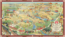
Decorative map of Rhode Island, drawn by Phillips D. Booth under the auspices of the Rhode Island Secretary of State's office in 1939.
The map's perimeter is adorned with an encyclopedic display of the state's municipalities, arranged in alphabetical order, each accompanied by its heraldic emblem. This border not only frames the main depiction but also serves as an educational tableau of the state's civic heraldry.
Historic and civic pride is articulated through depictions of notable edifices, such as the First Baptist Church in Providence, an architectural vestige of 1775. The waters teem with a variety of vessels, echoing the state's maritime heritage, while leisure pursuits are represented by labeled golf courses. Cultural touchstones, including Wakefield's Theater-by-the-Sea and South Kingstown's Hannah Robinson Rock & Tower, are rendered in miniature, inviting inspection and discovery.
The map's northeast quadrant is reserved for a tribute to Roger Williams, Providence's esteemed founder, while the oceanic expanse below features a legend, which, at the time of publication, directed inquiries to Secretary of State J. Hector Paquin for further enlightenment on Rhode Island's offerings.