|
||

|

|
|

|
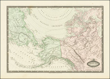
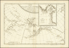
The First British Exploration of this Section of the Coast of British Columbia and Alaska - Discovered and Copied by the Spanish.
"When [this map] reached Mexico [it] seems to have awakened the Spaniards to the fact that they had not explored the mainland coast north of Vancouver Island to at least as far as 55°." - Wagner, page 233
This impressive 18th-century Spanish manuscript represents the first charting of some 700 miles of the coast of the Pacific Northwest, spanning from Clayoquot Sound on Vancouver Island to the vicinity of Sitka on Baranof Island, Alaska, possibly reaching as far north as Cross Sound. The chart originates from the surveys of Captain James Colnett during 1787-88. Colnett's explorations bridged the gap between Cook and Vancouver, and his efforts represented the first wave of British interest in colonizing the shoars and extending their influence across the Pacific. In 1789, his presence in the region and subsequent arrest by the Spanish naval officer Esteban José Martínez sparked the Nootka Crisis, a significant diplomatic confrontation between Britain and Spain that highlighted the intense international rivalry and territorial disputes in the Pacific Northwest during that era.
This chart traces its creation to a meeting between Colnett and Francisco de Eliza in Nootka in 1791. Colnett had returned there from San Blas to take repossession of the Argonaut, which had been seized in 1789. Colnett allowed Eliza to copy the chart. Today, there are only three of these contemporary manuscript copies extant: the present example, another one we have handled, and one in the Museo Naval, Madrid. Eliza sent his copy back to Mexico, where, according to Wagner and others, it caused quite a stir. Thanks to Colnett's map, the Viceroy realized how little information the Spanish had on the coast directly north of Vancouver Island, and he subsequently launched the Caamaño expedition of 1792.
The chart includes insets showcasing Puerto de San Jaime (Rose Harbour, Kunghit Island) and Puerto Brooks (east of Brooks Peninsula, Vancouver Island). It is notable for its late and intriguing depiction of the mythical Strait of Admiral de Fonte.
Colnett's Expedition
Captain James Colnett's expeditions to the Pacific Northwest, between 1786 and 1791, were driven primarily by the lucrative fur trade, particularly in collecting sea otter pelts. Colnett, a British maritime fur trader, embarked on his first fur trading voyage from 1786 to 1788, commanding the 171-ton ship Prince of Wales and the 65-ton sloop Princess Royal. These voyages were part of a new trade system, including wintering in the Hawaiian Islands and selling the pelts in Canton, China, where the British East India Company had a trading post.
Following Cook's Third Voyage and the colonization of Botany Bay, the British Empire, driven by its expansive colonial ambitions, contemplated the establishment of a colony in the Pacific Northwest. This strategic move was part of their broader vision to extend their global influence and control key trading routes throughout the Pacific. The idea was to populate and supply this new colony not from Britain, but rather from its then-recently established colony in Australia. This plan showcased the British Empire's logistical ingenuity and strategic foresight. By using Australia as a base, the British aimed to shorten supply lines and facilitate quicker, more efficient colonization and trade in the Pacific Northwest.
In 1789, Colnett aimed to establish a permanent British settlement and trading post at Nootka Sound on Vancouver Island, an area frequented by British and Spanish mariners for the fur trade. However, his presence was seen as an intrusion by the Spanish, leading to his arrest by the naval officer Esteban José Martínez, who seized his vessels, the Argonaut and Princess Royal.
This incident occurred amidst a period of intense exploration and territorial claims in the Pacific Northwest. In July 1787, Captain C. W. Barkley, aboard the Imperial Eagle, identified an opening he believed to be the long-lost Strait of Juan de Fuca. This was followed by brief visits from trading ships, including Robert Gray in the Lady Washington, who reportedly circumnavigated what is now Vancouver Island. Spain, asserting its sovereignty, expedited its exploration efforts through expeditions like those of Quimper, Eliza, and Galiano.
In 1791, as Colnett prepared to leave Nootka in the repossessed Argonaut, he allowed Eliza to copy the map charting his movements along the Northwest Coast during his 1787-88 visit. This map, which suggested the existence of De Fonte's strait or river at latitude 53° N, was sent by Eliza to the Mexican Viceroy, prompting further exploration. The subsequent Caamaño expedition of 1792 was a significant part of Spain's effort to explore and assert its claims in the region, overlapping with the arrival of Vancouver and Galiano on the coast.
Colnett's information would also make it into the second state of the Faden-Roberts Cook Map.
A Voyage to the North West Side of America: The Journals of James Colnett, 1786-89, Edited by Robert Galois, page 69:
Caamano's voyage in 1792 to the coast of British Columbia, in the vicinity of Banks Island, was also stimulated by information derived from Colnett's first expedition. During his return to Nootka, on the Argonaut in January 1791, Colnett allowed the Spanish commandant, Francisco de Eliza, to copy a map showing his movements on the coast during the voyage of 1787-88. The map, likely a version of Colnett MAP 1 (see p. 285), covered the coast from 49°N to 58°N. If so, it showed several "incomplete" inlets in latitude 53°N, the area where De Fonte was supposed to have found his strait or river, as well as Colnett's speculations on the topic. Eliza sent a copy of Colnett's map to the viceroy in Mexico, who promptly decided to have that area explored: the "result was the Caamano expedition of 1792."
Sotheby's:
The most important eighteenth-century coastal chart of the American Northwest. It extends northwards from "Pto de Clayocuat" [Clayoquot Sound, Vancouver Island] to a point in the vicinity of Sitka on Baranof Island, Alaska, and includes two small detached insets of "Puerto de S Jayme" at thesouthern end of "Ysla de la Ynfanta" [Queen Charlotte Islands], and "Puerto Brooks" [Klaskish Inlet, Vancouver Island]. The chart shows the detailed results of the survey carried out by Captain James Colnett in 1791 while in command of the London Company vessel, Argonaut. It was by the Spanish from Colnett's sketch which was handed over to Francisco de Eliza the Spanish commander in early 1791.
Colnett explored the coasts between 1788 and 1791 in company with Charles Duncan of the Princess Royal, having sailed from Canton in China. Part of his track (from information passed over to English ships en route) is marked on Arrowsmith's large World map of 1790. Wagner notes that Colnett's chart "when it reached Mexico seems to have awakened the Spaniards to the fact that they had not explored the mainland coast north of Vancouver Island at least as far as 55°. They had some knowledge of that part of the coast derived from the fur-traders, but it obviously required attention on their part" (Wagner, p.233). Of particular interest is what is perhaps the last appearance of the mythical Strait of Fonte, marked on the chart as "Estrecho del Almte. Fonte." Colnett believed that he had discovered the western end, and later expeditions (under Jacinto Caamano) were sent to verify this fact--albeit without success (Wagner 780).
Rarity
There are three known contemporary manuscript copies of this map:
1. The present example.
2. Another example sold at Sotheby's in 1984, which we have also handled.
3. Another example, in the Museo Naval, Madrid. Wagner 780: "Carta reducida que contiene parte de la Costa Septentrional de Californias desde los 49° hasta los 58° de Latitud N. Reconocida, y descubiertos sus puertos, bocas è yslas por el Capi- tan del Paquebot y Balandra Princesa Real arre- gladas sus latitudes, y longitudes, y nombres de sus puertos al original que dicho Capitan Don Jayme Collnett le presento por gracia particular al Coman- dante de este establecimiento Don Francisco Eliza en Febrero del Año de 1791. MS, 44.5x54 (ph.), a copy of Colnett's map made in Nootka. Contains two insets: Puerto de San Jayme at the southeast end of Queen Charlotte's Island in 52° 08′ and Puerto Brooks in 50° 11'."
Provenance
Sotheby's, Atlases, Travel and Natural History, 13 April 1989, lot 389. ("Only three examples of the chart appear to be known: the Museo Naval, Madrid copy; a copy sold in these Rooms (22 May 1984, lot 349); and the present example."); Private American collection.