|
||

|

|
|

|
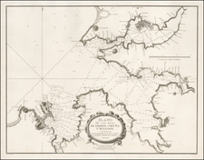
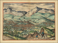
The First Printed Modern Map of Spain and Portugal.
A nice example of Francesco Berlinghieri's map of modern Spain, the first printed modern map of Spain, from his famed Septe Giornate della Geographia di Francesco Berlinghieri (The Seven Days of Geography), published in Florence in 1482. Of the maps from Ptolemy that preceded Berlinghieri's, neither the 1477 Bologna Ptolemy nor the 1478 Rome Ptolemy included modern maps of Spain.
Berlinghieri's map varies considerably from the other modern map of Spain issued in 1482. Leinhart Holle's map of modern Spain, a woodcut first issued in Ulm in 1482, has an entirely different arrangement of mountains, a thinner peninsular shape, and extends to more outlying islands, such as the Azores. As a more focused engraving, Berlinghieri's map has more detail than Holle's.
The map covers all of the Iberian Peninsula, delineating the Kingdoms of Spain and Portugal, the Emirate of Grenada ("GRANATA", still under Muslim control when this map was issued), and the Principality of Catalonia. Major regions, such as Navarre, Biscay, Galicia, Castile, and Andalusia, are named. The eastern extent of the map covers the Balearics with the exclusion of Menorca.
Sources
According to Peerlings and Laurentius (page 24), Berlinghieri's modern map of Spain is an evolved representation influenced by earlier manuscript maps created by the Florentine miniaturist Pietro del Massaio. These manuscripts, dating from before 1456 to 1472, contained similar maps of Spain, France, and Italy and were noted for their resemblance to each other, yet with varying representational techniques. The striking similarity between these manuscript maps and those in Berlinghieri's printed version of the Geography indicates a continuation or adaptation of the same cartographic tradition. Berlinghieri's printed map, therefore, represents an improved version of these earlier works, situating it within a lineage of evolving geographical knowledge and cartographic practice, incorporating elements from both portolan charts and Ptolemaic maps.
Berlinghieri: A Unique Tradition of Cartography
The cartography of Francesco di Niccolo Berlinghieri is viewed as a distinct tradition within the framework of Ptolemaic mapmaking. Most scholars agree that Belinghieri used sources different from his contemporaries to delineate the world's land masses. The configuration of the Mediterranean, in particular, appears to have drawn on alternative sources. A common explanation is that Berlinghieri, as a Fiorentine, had access to far older and more accurate portolan charts and possibly even sources from within the Islamic world. Unfortunately, confirming what those alternative sources might have been remains speculative.
An important distinction between his Ptolemaic atlas and other 15th-century versions was Berlinghieri's deliberate use of the archaic homeothermic or equidistant cylindrical projection, which is attributed to Ptolemy's predecessor and primary source of geographic information: Marinus of Tyre (c.100 CE). As far as we know, Ptolemy never actually made maps himself, so we do not know which projection he favored.
Nevertheless, by the time the first Ptolemaic Geographies were going into print, most mapmakers had shifted to the new trapezoidal projection attributed to German cartographer Donnus Nicolaus (c.1420-1490).
Cartographic scholar Peter Meurer points out that all known Ptolemaic Geographies from the 15th century were built directly on the manuscripts of Donnus Nicolaus but that Nicolaus himself used different projections over time. While the new trapezoidal projection, known as the "Donis-projection," was used in the Rome Ptolemy and the influential maps of Henricus Martellus, the Ulm edition returned to an equidistant cylindrical projection in order to present the new and updated understanding of Scandinavia based on the work of Danish cartographer Claudius Clavus.
Berlinghieri's Septe Giornate is the only 15th-century atlas to use multiple projections depending on what parts of the world were being presented. The creative process behind the Septe Giornate thus differed from that of contemporary Geographies.
Francesco Berlinghieri (1440-1501) was a Florentine engraver. Nicolas Laurentii published Berlinghieri's edition of Ptolemy, which was written in Italian terza rima, comprising 123 folios of text and 31 engraved maps. The work was first printed in 1482, but most surviving examples come from the edition of 1486, which was the first edition to include red printing in the title page. The full title is Geographia. In Questo Volume Si Congengono Septe Giornate Della Geographia Di Francesco Berlingeri Fiorentino Allo Illustrissimo Federigo Duca . . .
Berlinghieri's edition of Ptolemy is unique, in that it includes 31 maps covering Europe, northern Africa and the south part of Asia and is the first atlas to attempt the introduction of modern geography, with the inclusion of four new maps - France, Italy, Spain and Palestine, which are based on contemporary knowledge. rather than a strict plotting of Ptolemy's coordinates. A number of other maps in the Berlinghieri edition of Ptolemy include data which is drawn from modern sources, albeit more subtlely so, in part because of transcription errors and in part because of corrections made over time by later scholars.
While Berlinghieri's atlas was the third Italian printed edition of Ptolemy, it was very important in other respects. Berlinghieri's Ptolemaic regional maps are drawn on Marinus' plane projection; and although not generally considered an edition of Ptolemy, the maps are the only examples of Ptolemy's maps to be drawn on the original projection, with equidistant meridians and parallels. Berlinghieri's work was also the first to include a printed Gazetteer for each of the maps.
The text by Berlingheiri is a metrical paraphrase of Ptolemy, the first atlas in the Italian language. Francesco Berlinghieri was an Italian scholar and humanisrt. He promoted the value of classical Greek learning and therefore was the first to print an edition of Ptolemy in vernacular Italian, rather than Latin. The maps look distorted as compared to modern maps, because Ptolemy's data was inaccurate. One reason is that Ptolemy estimated the size of the Earth as too small: while Eratosthenes of Cyrene, a Greek mathematician, elegiac poet, athlete, geographer, and astronomer, made several discoveries and inventions including a system of latitude and longitude and conceived the idea of 700 stadia for a degree on the globe, in the Geographia Ptolemy uses 500 stadia. It is not certain if these geographers used the same stadion, but if we assume that they both stuck to the traditional Attic stadion of about 185 meters, then the older estimate is 1/6 too large, and Ptolemy's value is 1/6 too small. Because Ptolemy derived most of his topographic coordinates by converting measured distances to angles, his maps get distorted. So his values for the latitude were in error by up to 2 degrees. For longitude this was even worse, because there was no reliable method to determine geographic longitude.
Ptolemy was well aware of this. It must be added that his original topographic list cannot be reconstructed: the long tables with numbers were transmitted to posterity through copies containing many scribal errors, and people have always been adding or improving the topographic data: this is a testimony to the persistent popularity of this influential work in the history of cartography..
As early as 1938 Arthur M. Hind, Keeper of Prints and Drawings at the British Museum, hinted that the engravings might have been made by Francesco Rosselli (1448-before 1527), the principal engraver in Florence in the 1480s and 1490s. Subsequently, this possibility was rejected by Roberto Almagiagrave, R. A. Skelton and Tony Campbell. In the author's view, however, both stylistic and circumstantial evidence argues that Francesco was indeed the engraver, and that this first major commission launched the career that eventually made him known to his contemporaries as 'Franciscus rosellus florentinus Cosmographus'.