


|
||

|

|
|

|
Janet Taylor's Astronomical Work
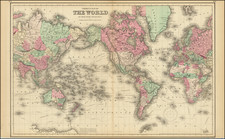
These charts are the work of Janet Taylor, a female astronomer and nautical navigation expert. Taylor published these charts in 1852 to illustrate the scientific idea of Great Circles. The two charts are complimentary to each other. One, a standard map of the world, illustrates the globe with major ports and landings noted. The second page is a projection of lines of latitude and longitude that can be used to calculate the shortes distance between two locations. Together, these charts form the basis for more efficient navigation using the idea of Earth's Great Circles.
Great Circles are a fundamental concept in geography that illustrates the intersection of a point on a sphere and the center plane. In the context of Earth, great circles are longitudes with the equator being the centralized location. Great circles can be used to calculate the shortest distance between two points on the planet's surface, an important concern for naval navigation. Following a great circle route minimizes the distance traveled, which, in turn, minimizes the time, risk, and associated costs of a voyage.
Janet Taylor
A pioneering astronomer and naval navigation expert, Janet Taylor was an influential female scientist in England during the 19th century. Born in England in 1804, Taylor was a brilliant child who was educated from an early age at the prestigious Queen Charlotte’s Royal School for Embroidering Females. It was here that Taylor developed her affinity for mathematics and astronomy which informed her life's work. Taylor attended the academy until its closure in 1818 when she moved to another academy to finish her studies.
Following the death of her father in 1821, Taylor invested her inheritance to further her scientific aspirations and research. The main facet of Taylor's work was producing new calculations for maritime navigation. Naval tradition operated under the idea that the world was perfectly spherical, accepting that their calculations would be slightly off due to the reality of Earth's dimensions. Taylor calculated more accurate projections of the Earth and definitively proved the planet was spheroidal. This information was published in her 1833 book Luni-Solar and Horary Tables. The work done in Luni-Solar inspired Taylor to invent an improved sextant, known as the Mariner's Calculator. Patented in 1834, the invention made it easier for sailors to measure the angles and distances of their course as it accounted for various mathematical truths of the world. Despite the revolutionary nature of the Mariner's Calculator, the British Admiralty would not adopt Taylor's device.
Undeterred by this failure, Taylor used her mathematical and technical know-how to start a business which specialized in creating and attuning nautical instruments. Operating under her husband's name, Taylor founded the George Taylor Nautical Academy and began to produce nautical instruments and charts. Due to Taylor's scientific knowledge, her shop was well-regarded by naval entities like the East India Company and the British Admiralty. Taylor continued to operate her business throughout the mid-1800s, eventually opening a secondary location called Mrs. Janet Taylor's Nautical Academy and Navigation Warehouse which specialized in training people how to use naval charts and navigate with nautical instruments.
Throughout the mid-19th century, Taylor operated a successful business and continued her scientific research. This work brought Taylor into contact with many of England's influential scientists and leaders. Throughout her later life, Taylor would be honored by King Edward VII, Prince Albert, and the Pope for her nautical innovations. Taylor also worked closely with renowned scientist George Biddell Airy to develop a way for iron-plated ships to use magnetic compasses to navigate, a major breakthrough for the 1850s.
Taylor continued to publish new works and improved editions of her nautical calculations. Due to her significant contributions to British maritime activities, Taylor was granted a Civil List pension of 50 pounds in 1860. Janet Taylor died on January 26, 1870, at age 65. Although her contributions were largely overlooked and her legacy buried, Janet Taylor's story is a fascinating tale of perseverance and ingenuity.
Rarity
The pair of charts are extremely rare.
OCLC locates 1 copy of each chart (University of Amsterdam Library).
We note the British Museum's accession of the maps in its 1884 Catalogue of Printed Maps, Volume 1-9, Part III, Page 152.
![[17th Century Provenance!] Universalis Tabula Iuxta Ptolemaeum](https://storage.googleapis.com/raremaps/img/small/72635.jpg)
![[Illuminated World Map -- There is no region of the world which Jesus, like the sun, does not enrich...] Orbis nulla plaga est quam sol non ditet Iesus...](https://storage.googleapis.com/raremaps/img/small/62347.jpg)
![[ World ] Air France -- Sur Les Ailes D'Air France Decouvrez Le Monde A Votre Tour](https://storage.googleapis.com/raremaps/img/small/100053.jpg)