|
||

|

|
|

|
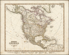
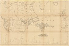
Detailed map of North America, publishedin London by John Wyld.
The map was published shortly after several important changes in the boundaries of the Western United States. The map shows the a boundary with Mexico following the end of the Mexican War, reflecting the results of the Treaty of Guadalupe Hidalgo (1848), but pre-dating the Gadsden Purchase (1854). Texas is shown following the compromise of 1850, which resulted in the creation of New Mexico Territory in its present configuration (pre-dating the formation of Arizona Territory), ending Texas claims to the area east of the Rio Grande, in exchange for payment of the debts of the Republic of Texas by the United States.
A massive Oregon Territory is shown (covering all of the future Idaho and Washington), and Missouri Territory (covering the area of the future Wyoming, Montana, Colorado, Nebaska and Kansas, the latter two of which would be formed in 1854.
James Wyld Sr. (1790-1836) was a British cartographer and one of Europe’s leading mapmakers. He made many contributions to cartography, including the introduction of lithography into map printing in 1812.
William Faden, another celebrated cartographer, passed down his mapmaking business to Wyld in 1823. The quality and quantity of Faden’s maps, combined with Wyld’s considerable skill, brought Wyld great prestige.
Wyld was named geographer to Kings George IV and William IV, as well as HRH the Duke of York. In 1825, he was elected an Associate of the Institution of Civil Engineers. He was one of the founding members of the Royal Geographical Society in 1830. Also in 1830, his son, James Wyld Jr., took over his publishing house. Wyld Sr. died of overwork on October 14, 1836.
James Wyld Jr. (1812-87) was a renowned cartographer in his own right and he successfully carried on his father’s business. He gained the title of Geographer to the Queen and H.R.H. Prince Albert. Punch (1850) described him in humorous cartographic terms, “If Mr. Wyld’s brain should be ever discovered (we will be bound he has a Map of it inside his hat), we should like to have a peep at it, for we have a suspicion that the two hemispheres must be printed, varnished, and glazed, exactly like a pair of globes.”