|
||

|

|
|

|
Stock# 98696
Description
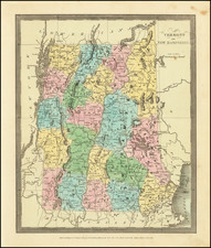
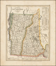
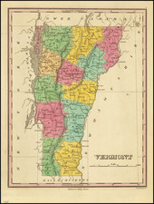
The first edition of the first map of Vermont to appear in an Atlas published in America, Guthrie's Geography Improved.
Engraved by Amos Doolittle in New Hampshire for Carey's edition of Guthrie's Geography, the map includes the names of the counties and townships of Vermont. Most notably, the map shows Dartmouth College in Hanover which had only opened a few decades prior in 1769. Perhaps one of the earliest depictions of the college on a map.
The Connecticut and Hudson Rivers are also depicted bordering the state. A very nice and early map of the region.
Condition Description
Light foxing as pictured. Expected toning from folding.
Reference
Wheat & Brun 195; Cobb, D.A. (VT) 118.