|
||

|

|
|

|
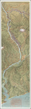
Attractive separate topographical map of Crater Lake National Park, in Oregon. This is a reproduction of the 1933 edition of the map released for public sale by the U.S. Interior-Geological Survey in 1957
A main feature of this map is the colored topographic lines, roads, and waterways. In the key there is an explanation of the different roads in the region: Medium duty, light duty, unimproved, and the State Route. The roads are illustrated in red or dashed black, leaving a subtle yet distinct impression on any area they are in. Similarly, the light blue that is used for Crater Lake is eye-catching and the initial draw to this map. Brown topographic lines compliment the cream background and make for a thoroughly attractive map of the area.
Although a rerelease, the map contains the same elegant charm as the original 1933 edition. Despite an updated 1946 edition existing, this map does not include any of the additional information added. This choice implies that this chart was meant for consumer decoration or collection, not practical navigation. An excellent display piece.
![[Report and] Map of an Exploring Expedition to The Rocky Mountains in the Years 1842 and to Oregon & North California in the Years 1843-44 By Brevet Capt. J. C. Fremont of the Corps of Topographical Engineers . . .](https://storage.googleapis.com/raremaps/img/small/88488.jpg)