|
||

|

|
|

|
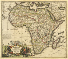
"This map is a testament to Italian cartography... It is probably the single most important and influential map of Africa of the sixteenth century. It represents a quantum leap from Sebastian Münster's significant Africa map of 1540." - Betz 9
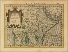
Giacomo Gastaldi's 1564 wall map of Africa, engraved and published by his collaborator Fabio Licinio, is a cornerstone in the cartographic representation of the African continent. Although its publication follows the maps by Paolo Forlani from 1562 and 1563, it is believed to have been completed years prior. Bifolco & Ronca (93) assert that publication was delayed until 1564, specifically to dedicate it to Maximilian II of Habsburg (1527-1576), who was proclaimed King of the Holy Roman Empire in that year.
Correcting his much smaller 1554 map, Gastaldi improved the representation of Africa's west coast, moving the southern tip farther west. (In Münster et al. the Cape of Good Hope was some 10 degrees too far east.) Gastaldi included the Zembere River originating from the western Ptolemaic lake, traversing unnamed mountains, and eventually bifurcating into the Zambezi and Limpopo rivers towards the southeast coast of Africa. In the interior of Southern Africa, the ancient city of Great Zimbabwe is depicted as the twin cities of Zimbro and Simbaoe, located near well-known gold mines. In West Africa, the Niger River is illustrated flowing westward from Lago del Niger to the Atlantic, passing through lakes akin to Lake Chad and another labeled Lago Guber.
The map draws on a multitude of sources, including Gastaldi's own maps prepared for his Geografia di Tolomeo (1548), the painted wall map at Palazzo Ducale (1549), and maps prepared for Ramusio's Navigationi et Viaggi (1550). Moreover, topographic information was extracted from Volume I of Ramusio's work, supplemented by travel accounts from Francisco Alvares (Verdadeira informacão das terras do Preste João das Indias, Lisbon, 1540) and João de Barros (Décadas da Asia, 1552) for the interior lakes region, and Duarte (Odoardo) Barbosa's account of Southeast Africa. According to Sims (2003), Gastaldi also relied on nautical charts, evidently from Portuguese sources. Consequently, Gastaldi's map is the quintessential printed representation of the African continent from the 16th century, influencing many subsequent maps, such as Gerard de Jode (1569), Giovanni Francesco Camocio (1570-75), Donato Bertelli (1573), and Cornelis de Jode (1596).
Sims, Giacomo Gastaldi and The Four Continents (2003, 222):
Gastaldi for the first time gave them (that is, wall maps of the continents) adequate size and correct form, and flushed them out with a wealth of interior detail, even if not always correct. It will not be fanciful to say that he brought the extra-European world out of hiding and into open view for the first time, and, besides the fact that it is his cartography that informs the depictions of the extra-European world in the universal mapping efforts which began in the years immediately after, including the Italian composite atlases, Ortelius's Theatrum, De Jode's Speculum, the four-continent sets, and others, one cannot doubt that Gastaldi's works also played a great inspirational role in initiating these projects. Neither those projects, nor the idea for producing them could ever have arisen without the preceding efforts of Gastaldi.
States and Rarity
The map is extant in only a handful of copies. 8 of the 20 known exemplars lack the southwestern sheet depicting the Atlantic Ocean with its sea monsters (present here in expert facsimile), a consistent absence suggesting this sheet was deemed nonessential for a comprehensive depiction of the continent. Subsequent to its initial publication, the map underwent a reprint in 1565, which introduced three descriptive cartouches. The only known copy from this state is preserved in the collection at the Biblioteca Nazionale Marciana in Venice, lacking the lower western sheet.
Bifolco & Ronca list the following examples.
First state (eight sheets): Basel, University Library; Greenwich, National Maritime Museum (2); Helsinki, University Library; Madrid, Royal Palace Library; Milan, Bertarelli Collection; Modena, Estense Library; Paris, National Library; Paris, Sorbonne Library; Rome, Alessandrina Library; Stanford, University Library; Wrocław, University.
First state (seven sheets): Chicago, Newberry Library; Florence, Marucelliana Library; London, British Library; Madrid, National Library; Milwaukee, American Geographical Society; Munich, Bavarian State Library; Vilnius, University Library.
Second state (seven sheets): Venice, Marciana Library.
Giacomo Gastaldi (1500-1566) is considered the foremost Italian cartographer of the sixteenth century, alongside Paolo Forlani. His skills of compilation are comparable to those of Mercator and Ortelius, yet much less is known of his life than of his two contemporaries. Gastaldi was born in Villafranca, Piedmont, but had established himself in Venice by 1539. He originally worked as an engineer, but turned to mapmaking from the 1540s onward.
It was in Venice where he made his reputation as an engraver, geographer, and cosmographer; for example, he was asked to fresco maps of Asia and Africa in the Palace of the Doge, or the Council of Ten, Venice’s governmental body. He also frequently consulted on projects for the Savi sopra la Laguna, drawing maps for this body which oversaw the regulation of fresh and salt water around Venice.
His contemporaries also recognized his skill, as he was named cosmographer to the Republic of Venice, was a member of the Accademia Veneziana, and was a major source for other geographers and mapmakers including Camocio, Bertelli, Cock, Luchini, and Ortelius. He even had his own distinct style of copper engraving that made him a pioneer in his day and makes his works iconic today.
Gastaldi enjoyed an especially productive relationship with Giovanni Battista Ramusio, Secretary of the Venetian Senate, who used Gastaldi's maps for his famous travel account collection, Navigationi et Viaggi. Gastaldi also tutored Ramusio's son in cosmography.