|
||

|

|
|

|
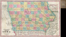
The Rarest Atlas Map of Iowa Territory
Extremely rare map of Iowa, published Tanner's New General Atlas, published in New York City by Tanner's Geographical Establishment, written and engraved by Joseph Perkins.
Iowa was organized as a Territory in 1838. The initial 20 counties extended to the Indian Treaty Line. The counties west of the line did not appear until after 1843 (Blackhawk, Tama, Powesheik, Mahaska, Kishkeekosh, Appanoose, Davis, Walpello Keokuck, Iowa, Benton and Buchannan).
The map is dominated by the Indian Lands of the Iowas, the Sauks and Foxes and the Sioux, along with a wide swath of Neutral Land separating the latter two tribes. This map shows the Indian Lands as technically a part of Clayton County, as per the 1840 Census. This map shows the extent of the early state surveys, counties, towns, courthouses in each county, roads, rivers, lakes and Indian detail.
Tanner's New General Atlas was issued following Tanner's sale of his Universal Atlas to Samuel August Mitchell. The Universal Atlas, which had been published in Philadelphia from 1836 to 1845. Tanner's New General Atlas, for which Anthony Finley was also a collaborator, is one of the rarest 19th Century American atlases. To view the complete atlas in the David Rumsey collection, click here.
Rarity
The map is very rare. This is the first example we have ever seen on the market.

![[Uncaptioned image of two figures seated in front of a tipi, mounted albumen print]](https://storage.googleapis.com/raremaps/img/small/78744.jpg)