|
||

|

|
|

|
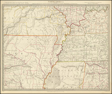
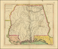
Surveying the American Border with Spanish West Florida
Detailed map of West Florida and the Lower Mississippi River Delta, drawn by Andrew Ellicott.
The map is the result of the first systematic attempt to survey the southern parts of Alabama, Mississippi and Louisiana, undertaken by the United States, shortly before the Louisiana Purchase.
Andrew Ellicott, a prominent figure in the annals of early American surveying, commenced his distinguished career in 1784 as a commissioner delineating the boundaries between Virginia and Pennsylvania. His surveying prowess was further recognized when he, alongside David Rittenhouse and Andrew Porter, was tasked with the definition of Pennsylvania's western boundary, a task he consummated in 1787 with the survey of the state's northern border.
In 1789, Ellicott relocated his family to Philadelphia, where he embarked on a commission by the federal government to survey the Presqu' Isle triangle—territory lying north of the forty-second parallel and south of Lake Erie. This significant project, which he diligently carried out until 1791, was a prelude to his monumental task in 1796 when President Washington entrusted him with the survey of the boundary between the United States and Spanish Florida, pursuant to a treaty with Spain.
Throughout his survey in the South, Ellicott meticulously documented both his observations and the impediments imposed by the Spanish authorities, culminating his work in the spring of 1800. Despite the subsequent withholding of his report by President John Adams, which led to a lack of compensation and financial strife for Ellicott, his published account in 1803 catapulted him to scientific renown.
The map was published in the The Journal of Andrew Ellicott for determining the boundary between the United States and the Possessions of his Catholic Majesty in America containing Occasional Remarks on the Situation, Soil, Rivers, Natural Productions . . . published in Philadelphia in 1803.
Andrew Ellicott (1754-1820) was an astronomer and surveyor. Prior to the Revolutionary War, Ellicott taught mathematics in Baltimore. A skilled surveyor, he conducted surveys of the Territory of Washington and the Mason-Dixon line. He also made the first topographical study of the Niagara River ad Falls. Ellicott was a member of the American Philosophical Society. He tutored Meriwether Lewis in astronomy before Lewis set out with Clark for their famous expedition. In 1813, Ellicott accepted a post as a professor of mathematics at West Point Academy. He died there in 1820.