|
||

|

|
|

|
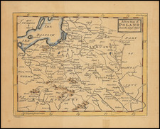
Rare separately published map of the Duchy of Warsaw, published in Vienna in 1810.
The present map is the seventeenth state of Tranquillo Mollo's map of the Duchy of Warsaw, which was first issued in 1807, the year in which Napoleon created the Duchy. Based upon Giovanni Antonio Rizzi Zannoni's wall map of Poland from 1772, this rare work lays out the newly formed Napoleonic Duchy in meticulous detail, along with the adjacent lands of Russia, Prussia, Curland, Pomerania, Silesia, Saxony, Bohemia and Moravia.
The map reflects efforts of Napoleon and his Polish allies to reconstitute the Poland. The Duchy of Warsaw was a French client state established by Napoleon Bonaparte in 1807, during the Napoleonic Wars. It initially comprised the ethnically Polish lands ceded to France by Prussia under the terms of the Treaties of Tilsit, and was augmented in 1809 with territory ceded by Austria in the Treaty of Schönbrunn. It was the first attempt to re-establish Poland as a sovereign state after the 18th-century partitions and covered the central and southeastern parts of present-day Poland. The duchy was held in personal union by Napoleon's ally, Frederick Augustus I of Saxony, who became the duke of Warsaw and remained a legitimate candidate for the Polish throne.
The map is colored quite curiously, with the area in pink being dissected by a brown boundary running north and south along the Bug River, which is the eastern border of the Duchy. Further east, within the larger pink outilne is a region which is now primarily Lithuania, Belarus and a large part of Western Ukraine.
The map is dense with details, including major roads through the region. Curiously, while dated 1810, the map does not fully reflect the transfer of West Galicia to the Duchy of Warsaw after the Treaty of Schönbrunn in 1809. While Krakow is now within the Duchy, the area to the south, including Tarnow, Lemberg (Lviv) and a large part of the southern part of West Galicia is outside the borders shown here.
The Changing Borders of Poland - Partition - Napoleon - Congress of Vienna
The geopolitical borders of Poland underwent significant changes in the late 18th Century and early 19th Century, a period marked by profound political upheavals and shifting alliances in Europe. The late 18th century was a tumultuous time for Poland, which saw its territory progressively carved up by its more powerful neighbors: Russia, Prussia, and Austria. This process, known as the Partitions of Poland, occurred in three stages (1772, 1793, and 1795), leading to the eventual disappearance of Poland as a sovereign state. The First Partition (1772) was a response to the weakening of the Polish-Lithuanian Commonwealth, with each of the three powers annexing parts of its territory. The Second Partition (1793) followed a failed attempt by Poland to reform and strengthen its government (the May Constitution of 1791), leading to further territorial losses, primarily to Russia and Prussia. Finally, the Third Partition (1795) was the death knell for the Polish state, with its remaining territory being completely divided among the three powers, effectively erasing Poland from the map of Europe.
The early 19th century, dominated by the figure of Napoleon Bonaparte, brought temporary but significant changes to the political landscape of Europe, including Poland. In 1807, following his victories against Prussia and Russia, Napoleon established the Duchy of Warsaw, a Polish state with a liberal constitution. This entity was a French satellite state, and its creation was part of Napoleon's broader strategy to weaken his enemies and redraw the map of Europe to his advantage. The Duchy of Warsaw, though short-lived, was a symbolic beacon of hope for Poles, representing a brief resurgence of Polish statehood and a reprieve from foreign domination.
The defeat of Napoleon led to the Congress of Vienna (1814–1815), a major diplomatic conference aimed at restructuring Europe after the Napoleonic Wars. The Congress's decisions had a lasting impact on the political order of the continent, including the fate of Poland. While the Congress did not restore Poland as a fully independent state, it did reconstitute a portion of its territory into the Congress Kingdom of Poland, under Russian sovereignty. This new political entity had a degree of autonomy, including its own constitution, army, and government, but it remained under the firm control of the Russian Tsar.
Rarity
The map is very rare.
![Sarmatia Utraque Europaea et Asiatica [Ancient Russia from both Europe and Asia]](https://storage.googleapis.com/raremaps/img/small/82027.jpg)