|
||

|

|
|

|
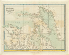
This map, created by Julius Payer on October 10, 1874, represents an early and significant cartographic depiction of the Franz Josef Land archipelago, as documented by the Austro-Hungarian North Polar Expedition. Published in Gotha by Justus Perthes as part of Petermann's Geographische Mittheilungen in the same year, it delineates the geography and exploratory routes of this remote and then recently discovered territory.
The 1873-1874 Austro-Hungarian North Polar Expedition, led by Julius Payer and Carl Weyprecht, was a landmark Arctic exploration. Aimed at finding a Northeast Passage, the expedition inadvertently became one of the first to navigate the Northeast passage when their ship, the Tegetthoff, became trapped in pack ice, drifting until it reached Franz Josef Land. Despite extreme conditions, the team conducted significant scientific research, mapping the newfound archipelago, and contributing valuable data on Arctic meteorology and geography. The expedition, marked by hardship and scientific triumph, remains a notable chapter in the history of polar exploration.
The map's creator, Oberleutnant Julius Payer, provided a visualization of the archipelago that includes intricate details of topography, glacial structures, and the expedition's route. It marks significant landmarks named by the explorers.
August Heinrich Petermann (1822-1878) is a renowned German cartographer of the nineteenth century. Petermann studied cartography at the Geographical Art-School in Potsdam before traveling to Edinburgh to work with Dr. A. Keith Johnston on an English edition of Berghaus’ Physical Atlas. Two years later he moved to London, where he made maps and advised exploratory expeditions as they set off to explore the interior of Africa and the Arctic.
In 1854, Petermann returned to Germany to be Director of the Geographical Institute of Justus Perthes in Gotha. There, he was the editor of the Geographische Mittheilungen and Stieler’s Handatlas. The Royal Geographical Society of London awarded him their Gold Medal in 1860. He continued his interest in exploration in Germany, fundraising for the German Exploring Expeditions of 1868 and 1869-70, which sought an open Arctic sea. Tragically, he committed suicide in 1878.
![[English Edition!] Maris Pacifici quod vulgo Mar del Zud](https://storage.googleapis.com/raremaps/img/small/71000.jpg)