


|
||

|

|
|

|
Stock# 98469
Description
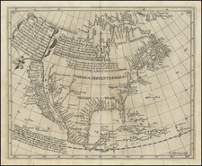
Scarce map of North America, published shortly before the sigining of the Adams-Onis Treaty.
The depiction of Louisiana, shortly after the Louisiana Purchase, shows the US Claims extending to the Rocky Mountains, with Mexico still shown as controlling the land south of the Columbia River, although the dashed line would shown running to Cape Orford would soon become the boundary.
The British claims to the land extending south to the Columbia River would soon be contested by the Americans, but the region would initially be shared by the two nations until the resolution of the so-called Oregon Controversy in 1846.
Condition Description
Minor toning and foxing throughout.


![[Pan American Menu Map] North America](https://storage.googleapis.com/raremaps/img/small/103976.jpg)