This item has been sold, but you can enter your email address to be notified if another example becomes available.


|
||

|

|
|

|
Stock# 98464
Description
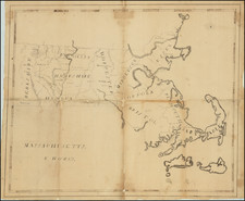
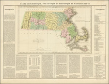
First American Atlas Map of Massachusetts
Nice early example of the first edition of Mathew Carey's map of Massachusetts, published in Carey's American Atlas in 1795 and General Atlas in 1796.]
The map shows hills, streams, county boundaries, main roads, towns and islands. Norfolk County does not appear.
This rare early state can be distinguished from later states by the lack of a page number in the upper right corner.
Carey's American Atlas was the first atlas published in the United States, compiling a number of excellent maps from indigenous sources in the first compilation of American maps. This map was engraved by J.T. Scott.
An essential map for Massachusetts Collectors.
Reference
Wheat & Brun 213.