|
||

|

|
|

|
Stock# 98411
Description
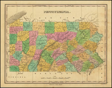
Nice example of the first state of Carey's map of Pennsylvania, from Carey's American Atlas, the first atlas of America printed in the United States.
This map includes the Erie triangle north of the 42nd parallel though evidence of an earlier erasure along the 42nd parallel suggests that the map was originally engraved by J.T. Scott (see Wheat & Brun 438).
Condition Description
Minor foxing
![[Includes Mail Road Timetable and Prices] Map of a Reconnaissance between Baltimore and Philadelphia Exhibiting the Several Routes of the Mail-Road Contemplated by the Resolution of Congress Approved on the 4th of May 1826](https://storage.googleapis.com/raremaps/img/small/82583.jpg)