


|
||

|

|
|

|
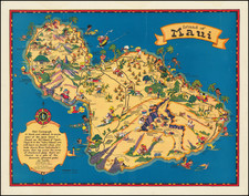
Early Hawaiian Tourism
Travel brochure for the Hawaiian islands that illustrates driving routes and points of interest for each of the Hawaiian islands. Produced by Chevron and the Standard Oil Company, the map aims to promote tourism to the recently accepted state of Hawaiin.
The main feature of the pamphlet is the five insets of detailed island maps of Hawaii, Maui, Oahu, Kauai, Molokai, and the orientation of the island group. All maps are richly illustrated with notable locations like Pearl Harbor, Waikiki, and Captain Cook's Landing depicted along the road. The inclusion of the different roads throughout the island illustrates how easy it is to travel from one place to another by car.
Inside the brochure is a well-done Street Map of Honolulu. This map features detailed illustrations of the city of Honolulu, with the various streets, neighborhoods, and points of interest displayed. The map color codes locations and roads to help a visitor distinguish between public, private, and governmental areas of Honolulu. The streets of the city along with their grid coordinates are also included, as is a list of points of interest, airports, golf clubs, and yacht clubs. All around a nice brochure designed to encourage tourists in Hawaii to drive the island and see the sights.
![Wailuku [Maui]](https://storage.googleapis.com/raremaps/img/small/61147.jpg)
![[Hawaii] Le Isole di Sandwich Delineate Sulle Osservazioni De. Cap. Cook . . . 1798](https://storage.googleapis.com/raremaps/img/small/91731.jpg)
![[ Honolulu ] Map of the Lower Part of The City of Honolulu and the Harbor Front. Compiled from Official Maps by A.B. Loebenstein. 1893.](https://storage.googleapis.com/raremaps/img/small/94593.jpg)