|
||

|

|
|

|
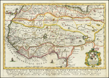
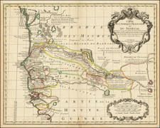
Map of North and West Africa After Pierre Du Val
Created in 1681 by Johann Hoffmann after a similar map by Pierre Du Val, Nigritia presents a detailed representation of West Africa, extending to the west coast and delving into the interior. The map, indicative of the cartographic knowledge of the late 17th century, shows regions, geographical features, and cities relevant to European exploration and trade endeavors in the continent at this time.
A main feature of the map is the relatively accurate coastline contrasted with an inaccurate interior. The northern part of the map is largely vacant with the vast expanse of the Sahara Desert, labeled as "Desertum," highlighting the formidable and uncharted nature of the continent. Further south, the map incorrectly depicts the Niger River simplistically extending across the continent which further underscores European limitations of cartographic knowledge during the period, as the Niger is a much shorter and more complex river system.
Several prominent regions and kingdoms are also included. Notably, the powerful kingdoms of Congo and Guinea are shown in addition to important cities in these empires. Among these cities are Tombuto (more commonly known as Timbuktu), a legendary center of trade and Islamic scholarship, and Agades, a crucial stop on trans-Saharan trade routes. The inclusion of these locations, which served as hubs of commerce, culture, and power, illustrates the increasing connection between Europe and Africa during this time period.
Through its detailed depictions, "Nigritia" offers viewers a window into the European understanding of the African continent at the close of the 17th century. While the map captures places of European interest in Africa with relative accuracy, it also reflects the limitations of Western geography at this time due to limited exploration and contact.
Pierre Duval (1618-1683) was a French geographer, cartographer, and publisher who worked in Abbeville and Paris during the seventeenth century. He was born in the former city, in northeast France, before moving to Paris. Duval was the nephew of the famous cartographer Nicolas Sanson, from whom he learned the mapmaker's art and skills. Both men worked at the royal court, having followed the royal request for artists to relocate to Paris. In addition to numerous maps and atlases, Du Val's opus also includes geography texts. He held the title of geographe ordinaire du roi from 1650 and died in 1683, when his wife and daughters took over his business.
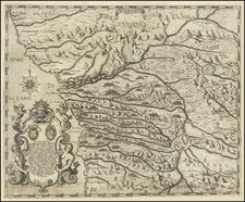
![(Congo Free State) Carta della stato independente del Congo. . . Eseguita dal Tenente Montuori Francesco [Map of the Congo Free State. . . Performed by Lieutenant Montuori Francesco]](https://storage.googleapis.com/raremaps/img/small/86019.jpg)