


|
||

|

|
|

|
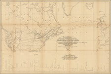
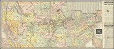
Detail-Rich Map of the United States, Based on Many of the Most Important Cartography of Its Time, With Major Updates
Scarce 1843 issue of this elaborate and important map of the United States published successively by the Brué and Picquet firms. The map compiled cutting-edge information from a host of contemporary sources and stands as one of the best French maps of the United States produced in the 1830s and '40s. The map is noteworthy, in particular, for its treatment of the Upper Midwest, Florida, and the West, of which the latter two received dedicated insets. This is the large version of two Brué maps with almost the same title and should not be confused with the smaller and more common edition. Due to its rarity, this map has not previously received the attention it deserves, an oversight we seek to remedy in this catalog entry.
The map's coverage is redolent of a few of the largest and most detailed wall maps of the United States published in the preceding decades, namely David H. Vance's 1825 Map of the United States Of North America and 1827 Walker brother's Map of the United States, which was based on Vance. Indeed, Brué included a lengthy note about the map's sources below the title block, indicating his reliance on the Walker map and Tanner's 1829 United States of America. Unlike the Walker and Vance maps, Brué's map provides detailed insets covering Newfoundland and major U.S. cities such as Boston, Philadelphia, and New York. Most importantly, this map includes an intricate inset of what was, at the time, the West of the United States (i.e., less the Southwest, then still part of Mexico). This inset benefited from Brué and then Picquet's ground-breaking work on the Nouvelle Carte Du Mexique, Du Texas Et D'Une Partie Des Etats Limitrophes, which Wheat called one of the "foundation stones of Western mapping history." The massive "Territoire de L'Oregon" has been left ambiguously open at its northern extent, without the publisher's hand-coloring closing in the American territory there. Great Britain and the United States would not resolve that border until the Oregon Treaty of 1846.
Where Brué has space, that is to say largely at the edges of the map where detailed cartography is lacking, he includes disquisitions on the history, politics, and peoples of the area.
Brué and Picquet's Nouvelle Carte générale des États-Unis, is an excellent example of mid-19th-century French cartography that reflects the rapid territorial and cartographic changes of that period of U.S. history.
Publication History and States
The map was initially issued by Brué in 1832, the same year he died. Brué's widow published maps under his name until 1835, when cartographer Charles Picquet acquired the firm. Picquet continued to update and publish new versions of this map until at least 1845. The publication of this map may have been discontinued after the mid-1840s due to the significant territorial change in North America that came after the Oregon Treaty (1846) and the Mexican-American War (1846-48).
- 1832: Contains Brué's notes on the mapmaking process, the geopolitical situation of North America, and the Western native territories. Subsequent editions would copy these notes verbatim. Does not have clearly marked state boundaries for Iowa or Missouri. Significant indigenous presence seen in West.
- 1836: Substantially updated from the first state. Additional rivers, settlements, and forts in Florida, Iowa, Missouri, and Michigan. Several toponyms have been changed or corrected.
- 1839: Unexamined. We locate a single example, at BAnQ.
- 1840: Ft. Dallas (Miami) and Ft. Lauderdale added in Florida, along with a host of other changes (see the central chain of lakes). Iowa labeled. Missouri delineated. Oregon is now labeled a territory rather than a district, and additional names (e.g., Ft. Umqua) and rivers added to its coast. Diminished native lands in the West, especially in regions previously populated by the Sioux. Coasts throughout the map are more cleanly marked.
- 1843: First appearance of Texas in the series. The colony at Bodega Bay labeled as Russian.
- 1845: Unexamined. A single example traced at Harvard.
It is also worth reiterating there is a smaller second edition of this map with fewer insets.
It is possible that publication was carried beyond 1845 by the likes of Alexandre Vuillemin in the 1860s and '70s; however, we cannot confirm that the similarly-titled maps in OCLC from this period are later states of the map in question and not the smaller second edition.
Translation
The following is a translation from French of Brué's essay on the sources of the map:
To the knowledge acquired 15 years ago on the regions within the limits of the United States and neighboring countries, we sought to gather subsequent works in order to summarize in this map everything we have today: This study, showing that many errors have been replaced by more accurate documents, allows us to appreciate the degree of confidence due to discoveries made up to the early years of this century, as well as the extent of areas still unexplored or about which there are still doubts.
We will not recall here either the significant corrections made to the main astronomical positions that serve as the basis for the mapping of the middle part of North America; nor the many topographical works, which for the eastern regions, leave nothing to be desired; nor what is owed to the travels of Long at the foot of the Rocky Mountains or in the basin of the Rio. Pierre and around Lake of the Woods; nor the insights resulting from Schoolcraft's explorations of the Great Lakes region and the reconnaissance of commissioners responsible for delimiting the lands of the Union and British Possessions: We have already mentioned this while reporting (Bulletin of the Geography Society, Vol. 14), on the map of the United States published in 1829 by Tanner, a map that partly benefited, as did the one published in London in 1827 by the Walker brothers, these acquisitions, combined with many others less known. However, in coordinating these elements again, we extracted valuable data not even found on the maps attached to reports, although they can be used to rectify or complete previous discoveries, and they often facilitated the use of vague information, mostly provided by traders, which we still have to use. We also relied on descriptions from Hunt, Stuart, etc., who illuminated the regions south of those visited by Lewis and Clark more than the journeys of Storis, Anshley [i.e., Ashley], Smith, etc. The latter, after crossing, since 1824, the great plains between the Missouri and the Oregon Mountains, aimed to explore the northern regions of the Mexican Confederation; but, in pointing out map errors in their reports, they rarely provide ways to replace them with a summary of what they found. Further north, Harmon's journey and subsequent communications with the English settled on the northern tributaries of the Oregon or Columbia River, produced more favorable results: Other notable excursions of this kind also helped complete the details of the countries between the Great Lakes and the Missouri.
The study of available documents guided us in drawing the main terrain undulations. To prevent numerous errors, which are confirmed in Orographic and Hydrographic descriptions, we indicated in toises (an old unit of measurement) for over 130 main points, the absolute height above the Ocean, of Lakes, Rivers, Plains, Mountain Ridges, Isolated Mountains, watershed lines, and the highest points reached by Canals and Roads connecting the Eastern Coasts with Lakes Ontario, Erie, and the tributaries of the Ohio. However, among these figures, which show the elevations and depressions of the ground, some are only approximate; often they are derived from comparisons we made between results either from leveling lines executed in Eastern states or measurements taken by travelers in less-known Western regions.
Andre Hubert Brué was a French geographer and cartographer. Born in Paris, he served in the French Navy, joining the Baudin expedition to the Pacific (1800-1804). After his sea service, Brué applied his navigation and charting skills to creating finely-crafted maps, which were renowned for their crisp engraving and accuracy. He drew directly on the copper of the plate, creating what he called encyprotypes. He is best known for the Atlas universal de géographie physique, politique, ancienne et moderne.
![(Lasalle's Final Expedition) Dernieres Decouvertes dans L'Amerique Septentrionale de M. De La Sale [i.e., La Salle], Mises au jour par M. le Chevalier Tonti, Gouverneur du Fort Saint Louis, aux Islinois.](https://storage.googleapis.com/raremaps/img/small/69476.jpg)