|
||

|

|
|

|
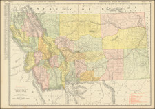
Wall Map of Montana Territory
Fine early map of Montana Territory, published by the General Land Office in 1897.
The map provides exceptional detail in the surveyed regions of Montana Territory, but also highlights just how much of Montana was as yet unexplored, unsurveyed and largely unmapped, other than primitive deails on watershed and topography. The detail in the map, based upon the most up to date government surveys, was the best available information to the General Land Office at the time of publication.
Includes a key showing the offices of the Surveyor General, Land Offices, Townships which have been subdivided, county seats, boundaries of land districts, railroads, military reservations, and Indian Reservations (yellow). Several Indian Treaties are also noted.
Yellowstone National Park appears at the bottom of the map, just a few years after it became a National Park.

![Map of Oregon, Washington and Part of Idaho [First Appearance Of Idaho Territory, including western Montana and Western Wyoming]](https://storage.googleapis.com/raremaps/img/small/94211.jpg)
![History of the Expedition under the Command of Captains Lewis and Clark, to the Sources of the Missouri Thence across the Rocky Mountains and Down the River Columbia to the Pacific Ocean, Performed During the Years 1804-5-6 [with map:] Map of Lewis and Clark's Track, Across the Western Portion of North America from the Mississippi to the Pacific Ocean](https://storage.googleapis.com/raremaps/img/small/92506.jpg)