|
||

|

|
|

|
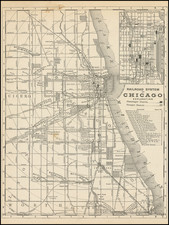
Prepared for The World's Columbian Exposition
This 1893 map presents a detailed view of Chicago, delineating its city limits with precision and clarity. The visual representation is marked by a prominent red line, enclosing the urban landscape just before the World's Columbian Exposition. Its practical layout labels streets, railways, parks, and important industrial zones, providing a clear depiction of the city's infrastructure.
The map draws particular attention to the sites of the World's Columbian Exposition, distinguished in red, indicating Jackson Park, Midway Plaisance, and sections of Washington Park. These annotations serve as informative guides to the fair's location in relation to the city’s broader geography.
Chicago's extensive park system, depicted in green, is integrated into the cityscape. These areas, vital to the city's recreational life, are easily identifiable, highlighting their presence amidst the dense urban grid.
Historically, the map reflects a period of significant expansion following the Great Chicago Fire of 1871, suggesting a narrative of recovery and growth. It functions not only as a cartographic record but also as a pointer to further resources, directing users to "The Standard Guide to Chicago" for an in-depth understanding of the city's elements.
The map's inclusion of waterways—the Chicago River and its branches, the Calumet River, and the lakes within the city—is detailed, yet unembellished, offering a straightforward depiction of Chicago's natural and man-made aquatic features.
Rand McNally & Co. is a large American map and navigation company best known for its annual atlases. The company got its start in 1856, when William Rand opened a print shop in Chicago. He was joined in 1858 by a new employee, Andrew McNally. Together, the men established their namesake company in 1868. Originally, the company was intended to print the tickets and timetables for the trains running to and through Chicago; their first railway guide was published in 1869.
By 1870, they had shifted from just printing to publishing directories, travel guides, and newspapers. Their first map appeared in 1872 in a railway guide. The map was produced using a new wax engraving method, a cheaper process that gave the company an edge.
By 1880 Rand McNally had entered the education market with globes, wall maps, and geography texts for students. In 1923, Rand McNally published the first Goode’s World Atlas, named after its editor, Dr. J. Paul Goode. For generations afterward, this would be the standard classroom atlas.
In 1899, William Rand left the company, but McNally and his family remained, controlling the company for over a century. In 1904, they published their first road map intended for automobiles and by 1907 were publishing Photo-Auto Guides, which combined photography and mapping to help drivers. In 1924, they produced the Auto Chum, a precursor to their famous road atlases. Rand McNally would remain the leader in road maps and atlases throughout the twentieth century.
In 1937, Rand McNally opened its first store in New York City. Ever on the frontier of technology, Rand McNally pioneered the scribing process for printing tickets in 1958 and printed their first full-color road atlas in 1960. Arthur Robinson developed his now-famous projection of Rand McNally in 1969. By the 1980s, the company was exploring digital reproduction and digital databases of maps for truckers. In the 1990s, they lead the charge to develop trip-planning software and websites. Today, most of its products are available online or in a digital format, including maps for tablets and phones.

![[ Chicago ] 1856 * * * View of the Chicago Harbor and Central Area](https://storage.googleapis.com/raremaps/img/small/99576.jpg)