


|
||

|

|
|

|
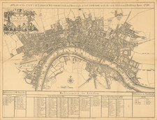
Rare map of Saxon London, circa 1000 A.D.
Fine example of John and Edward Wallis's rare map of London, as it looked during the time of the Saxons.
An historically speculative map showing London as it was imagined in Saxon times - circa1000. A panel of text beneath the map conveys that London was an important city even before the arrival of the Romans, including brief notes for the period A.D.61 to A.D.1086. The map shows Watling Street (with Trajectus Ferry) traversing the marshes on the south bank of the Thames before crossing the river and entering the city walls on the north bank at "Belins Gate". Two Roman burial sites are also depicted just outside the city walls. The "Mercat" forms the central hub of the city and streets emanate outwards from there
The map presents a compelling visualization of early London, a city already significant as a commercial hub long before the Roman conquest. The Thames, London's arterial waterway, bisects the city, while the Roman walls defining its perimeter imply a settlement of considerable importance and sophistication. Roads reach out like spokes from the historical gates in the wall, suggesting the routes along which trade and travel would have flowed in and out of the city. The map echoes London’s status as a center of trade and commerce, a status that attracted the Romans and which they expanded upon.
The fortifications depicted, particularly the Roman wall with its imposing gates and towers, speak to the era of Roman reinvestment and restructuring under Constantine in AD 306. The strategic positioning of the towers and gates along the wall, as well as the Barbican Speculum or Watch Tower, reflect the practical and military concerns that shaped urban development during the period. The London Stone, noted in the transcription as a Roman milestone, suggests the map may well align with Roman measurements and the administrative order they imposed upon the city, reinforcing London's role as a pivotal node in the vast network of Roman Britain.
The ecclesiastical and royal buildings shown include the first church on Cornhill, St. Gregory, Santa Maria, St. Peter, Santa Helena, St. Martin le Grand, St. Mildred and the first St Paul's Church would have been integral to the city's spiritual life and governance. Meanwhile, the White Tower, established by William the Conqueror, symbolizes the Norman layer of London's history, showcasing the city's continuous evolution under successive rulers. The map and text together illustrate a London that is both an ancient entity, with roots stretching back before the Common Era, and a living city, evolving with each new wave of conquerors and inhabitants.
Rarity
The map is very rare on the market. We note a single example in a dealer catalog going back 40 years (Jonathan Potter, 2010).
The text reads as follows:
London, long before the arrival of the Romans, was a place of great resort, and the principal mart of trade and commerce. Its situation was such as the Britons would likely select. An immense forest and morass covered its northern neighbourhood. It was defended, on the west, by a deep ravine called the River of Wells, on the east by another ravine since called Walbrook, and on the south by that noble stream, the Thames. A.D. 61, being in the possession of the Romans, it was attacked by the British Queen Boadicea, who nearly destroyed the place and put 70,000 of the inhabitants to the sword.
A.D. 306. The Romans, under Constantine, having regained possession of London, enlarged the city, and fortified it with a wall composed of rough stone and British brick. This wall was upwards of 3 miles in circumference, 9 feet thick, 22 feet high, and guarded by 15 towers, each 40 feet high. There were 5 gates which received the great military roads, besides two others on the side of the river for ships to unload at. A little without the walls to the NW of Cripplegate, stood the Barbican Speculum, or Watch Tower, which was a usual appendage to fortified places.
That relic of antiquity, still preserved under the name of London Stone, is supposed to have been placed in its present situation by the Romans 15 years before Christ as a standard from which they computed their distances. It stands in the line of the ancient Praetorian Way, called by the Saxons Atheling or Watling Street. There is a tradition that the first church founded in London was situated in Cornhill and dedicated to Peter by King Lucius, who died A.D. 181. It was made the See of a Bishop until removed to Canterbury. The first Church of St Paul's was built A.D. 610, said to have been erected on the foundation of an old temple of Diana, but this idea was disproved by Sir Christopher Wren. Arx Palatium, signifying a castle, fort, or royal palace, occupied the spot on which stands the present building called the White Tower, which was erected by William the Conqueror, A.D. 1078, to overawe his British subjects. Oldbourne, A.D. 1086, was a village consisting of a few houses on the brook of that name. Shoreditch, then known as Sordich, was a village situated on the Roman Military Way called Eald or Old Strete.
![[ London ] A New and Correct Plan of the Cities and Suburbs of London & Westminster Borough of Southwark with the Country adjacent the New Buildings Roads](https://storage.googleapis.com/raremaps/img/small/102623.jpg)
![[ London ] Londres](https://storage.googleapis.com/raremaps/img/small/101851.jpg)
![[New and Exact Plan of the City’s of London and Westminster and the Borough of Southwark And the Additional New Buildings Churches &c to the present Year 1735.] (Western sheet]](https://storage.googleapis.com/raremaps/img/small/62521.jpg)
![[A View of the West Side of London Bridge, with the Water Works, in the Year 1749, from an Engraving by S. and N. Buck]](https://storage.googleapis.com/raremaps/img/small/86989.jpg)
![[London - Great Fire of 1666 and Pollution Sammelband]](https://storage.googleapis.com/raremaps/img/small/103653.jpg)