|
||

|

|
|

|
Stock# 98219
Description
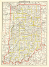
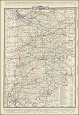
Rare separately published pocket map of Indiana, pubilshed by Edward Mendenhall in Cincinnati.
Includes a population table for Indiana, showing the population of each county in 1850 and 1860.
The map is hand colored by counties, and shows towns, post offices, rivers, roads (common, and Mcadamized), canals and railroads (finished and in progress). The National Road is prominently shown crossing through the middle of the state from Richmond to Indianapolis and Terre Haute.
States of the Map and Rarity
First issued issued in 1854, OCLC locates editions in 1855, 1865, 1866, 1867, 1870, 1873.
AMPR locates 2 examples offered for sale in the past 20 years.
Condition Description
Folding map in original cloth covers, with gilt-lettered title. Some evidence of soiling and wear and spotting.