


|
||

|

|
|

|
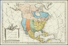
Transmississippi West on the Eve of the 1859 Colorado Gold Rush - With German Colony and French Colony in Texas.
Attractive large format map of the US & Mexico, featuring a very unusual speculative Colorado River.
California is shown a narrow "chili pepper" configuration, with a massive Utah Territory with a Utah territory to the east, pre-dating the creation of Nevada and Arizona. A newly created Washington Territory extends to the Rocky Mountains, including the northern part of the yet to be formed Idaho Territory.
Curiously shaped New Mexico Territory to the west of Texas and east of Utah Territory. Indian Territory is shown in its "tomahawk configuration." Masive Nebraska Territory above Indian Territory, extending to Canada and the Rocky Mountains (pre-dating Kansas, Montana, Wyoming and the Dakotas).
Texas is oddly configured and the French colony is highlighted in blue and a German Colony in yellow. Notably, Neu Braunfels and Friedrichburg in the earlier Verein zum Schutze deutscher Einwanderer in Texas (Society for the Protection of German Immigrants in Texas) are not shown in the German colony.
The oddest geographical feature is the tentative (dashed line) treatment of the Colorado River, Green River and "R. Grande", which have not yet been fully explored.
The pre-Gadsden Purchase border with Mexico shows that the map is a few years out of date.

![[ Exceptional original hand-color with highlights in gold ] Typus Aspectuum Oppositionum Et Coniunctionum Etz In Planetis](https://storage.googleapis.com/raremaps/img/small/81866.jpg)
![[ Massive Misplace Idaho Territory ] The United States of North America.](https://storage.googleapis.com/raremaps/img/small/99361.jpg)
![[School Girl Map] United States by Betsey C. Converse](https://storage.googleapis.com/raremaps/img/small/66109.jpg)