


|
||

|

|
|

|
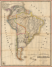
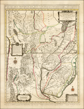
A fine example of Juan Francisco D'Avila's rare map of the Jesuit Provinces, first issued in 1726, corrected and enlarged in 1732 by Antonio Marchoni and reissued in Novelle interessanti in proposite degli affari del Portogallo . . . published in Bern in 1760.
D'Avila's map of the Paraguay was the most complete and up to date map of the region drained by the Rio de la Plata and a significant improvement over earlier maps of the region. The map extends from Peru, Lake Chucuito and the source of the Rio de La Plata at Xareyes Lacas to the mouth of the Rio de la Plata, Buenos Ayres, Mendoza, etc. The map shows the region of the central part of South America from Atlantic to Pacific Ocean, including most of Peru, Bolivia, Paraguay, Brazil, Uruguay, Argentina and Chile, with rivers and affluents, tribes territories and settlements. Indicates existing and destroyed Spanish towns and Jesuit missions. This map is substantially improved from earlier maps of the region, including a more accurate depiction of the two bays at Montevideo, the Parana Delta is more accurately depicted than in previous maps, the various sources of the Rio Uruguay are much more accurately depicted, etc.
As noted in Maps of the Jesuit Mission in Spanish America, 18th Century . . . Imago Mundi, Vol. 15, (1960), pp. 114-118:
This map, as is well demonstrated by Furlong, was the work of Fratello Juan Francisco Davila or d'Avila (1682-1733), being published in Rome under the care of the Procurator, Fr. Girolamo Herran. "This map is without doubt the most complete and most comprehensive map undertaken by the Jesuits up to the middle of the eighteenth century" (Furlong, S.J., Cartografia jesuttica del Rio de la Plata, I (Buenos Aires, 1936) p. 44). In 1732, another edition, revised and emended (by Fr. [Antonio] Machoni ?), was issued; this was twice reproduced: in the Novelle interessanti in proposite degli affari del Portogallo .. (Berna, 1760), in volume I or II, depending on the copies; and in the Sammlung der Neuesten Schrifften welche die Jesuiten in Portugal betreffen, II (Franckfurt, 1761) . . .
p. 117.
A remarkable two sheet engraving, with 4 cartouches and a compass rose. One of the rarest and most important maps of the region, catalogued in several major South American collections as a source map for much of the regional cartographic information of the period.