


|
||

|

|
|

|
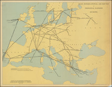
This postcard map, titled "Wer braucht Sicherheit im Osten?" ("Who Needs Security in the East?"), is an evocative artifact of interwar Germany, highlighting the military fortifications along the German-Polish border. It asks a poignant question set against the backdrop of national security concerns of the period following World War I and preceding the rise of the National Socialist government.
The map's legend categorizes military units and installations with distinctive symbols and colors, clearly designed to communicate the strength and distribution of forces. It includes classifications such as infantry divisions, cavalry divisions, infantry battalions, squadrons, and various artillery units, including lighter units equipped with anti-aircraft guns (flak). The presence of heavier artillery units, motorized units, and railway troops suggests a strategic emphasis on mobility and logistical support. Notably, the legend also specifies tank divisions, air regiments, and even airship divisions, reflecting the technological advancements in warfare.
From the standpoint of historical context, this map illustrates the precariousness of the Weimar Republic’s political situation. The geographic focus on Silesia, East Prussia, and the Polish Corridor underlines areas of particular contention due to their mixed ethnic compositions and economic importance. The military positioning evokes the uneasy peace and the Republic's defensive posture during a time when the Versailles Treaty's territorial rearrangements were still fresh and disputed.
The detailed symbols representing different military units stationed across the region not only demonstrate the organizational complexity of the Reichswehr but also signal the militarization of the border area during a volatile period. The map’s production by the Deutsche Luftbild-Dienst (German Aerial Photography Service) in Berlin further suggests its intended use as a tool for strategic military planning or propaganda to underscore the need for security and preparedness against potential external threats.
A collector or historian might appreciate this map for its intricate representation of military logistics, its reflection of the interwar geopolitical climate, and its implicit narrative of a nation grappling with its vulnerabilities. As a cartographic document, it holds value for its detailed depiction of a moment in time when the specter of war began to loom again over Europe. Analyzing the cartography, one could discern the strategic points emphasized by the cartographer, the communication lines deemed vital for defense, and the urban centers marked for their strategic or administrative significance.
![Kwajalein (Kwajalein Island / Kwajalein Atoll, Marshall Islands]](https://storage.googleapis.com/raremaps/img/small/77062.jpg)
![(Second World War - Anti-British Propaganda) Français regardez cette carte [French, look at this map!]](https://storage.googleapis.com/raremaps/img/small/88492.jpg)
![Daniae Regni Typus [with] Cimbricae Chersonese nunc Iutiae descriptio ..](https://storage.googleapis.com/raremaps/img/small/94423.jpg)