This item has been sold, but you can enter your email address to be notified if another example becomes available.


|
||

|

|
|

|
Stock# 98088
Description
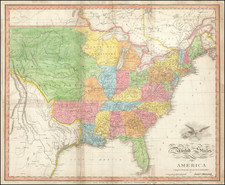
Fascinating map of the United States, published in Paris by Thierry.
The map shows the West on the eve of Texas Independence. Upper California is still part of Mexico. The 54-40 or fight border between Oregon Territory and British Columbia is shown, with a fantastic watershed in the north of what is labeled District de la Columbia in Missouri Territory.
The map pre-dates the formation of Wisconsin, Iowa and Minnesota, although a massive Northwest Territory is shown. The Transmississippi West is mostly rivers and early Indian names, including the Arropotous (Arapahoes), Cochones (Shoshone), Serpens (Snake) and the Big-Horn.
![[Map of the United States, illustrating the routes of the Canadian Pacific Railway and the Seattle, Lake Shore and Eastern Railway]](https://storage.googleapis.com/raremaps/img/small/71080.jpg)

![Louisiana [Large-Paper Example]](https://storage.googleapis.com/raremaps/img/small/83278.jpg)